Ditton Gold Property
Strategic Gold Property
Southern Québec | Near New Hampshire Border
A newly discovered paleoplacer gold channel in Chartierville, Quebec, near the U.S.–New Hampshire border, with extensive placer gold anomalies and strong geochemical and structural indicators supporting exploration for lode gold and the potential identification of the primary source of the placer deposits.
SECTION 1 — DISCOVERY STORY
A Modern Paleoplacer Gold Discovery
The Ditton Property hosts a newly identified gold-bearing paleoplacer channel located in southern Québec near the New Hampshire border. The discovery was made through systematic exploration combining historical records, seismic geophysics, sonic drilling and large-volume bulk sampling.
The project lies along the Bella Fault, a major regional structural corridor associated with historical placer gold occurrences and favorable geological contacts between the Compton and Frontenac formations.
The Ditton property extends for approximately 7 km along the Bella Fault trend.
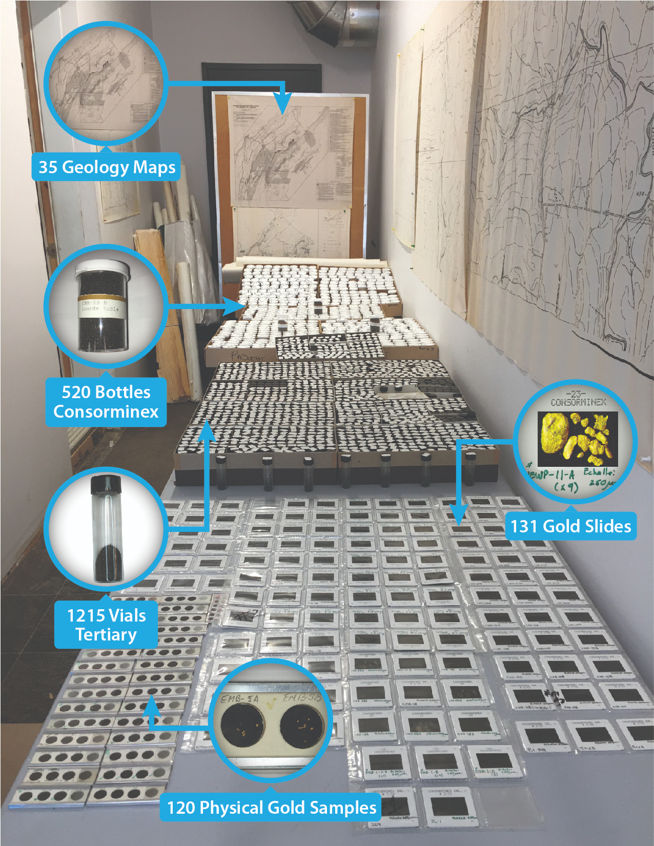
BGF acquired the life’s work of a dedicated local prospector—an unparalleled private collection of over 35 meticulously detailed geology maps, 520 Consorminex bottles, 1,215 Tertiary vials, 131 gold slides, and 120 physical gold samples, the vast majority of which had never been published.
SECTION 2 — WHY DITTON IS UNIQUE
A Rare Paleoplacer Exploration Opportunity
Why Ditton Stands Out
- Historic placer gold district with proven production nearby
- Newly identified buried paleochannel system
- Modern geophysical targeting defines prospective zones
- Sonic drilling confirms channel geometry and sedimentology
- Evidence of nearby bedrock gold sources
A Three-Part Exploration Model
- Near-surface placer gold potential in modern alluvium and gravels
- Buried tertiary paleoplacer systems preserved along the Bella Fault
- Potential lode gold source discovery in underlying bedrock
SECTION 3 — HISTORIC GOLD DISTRICT
Historic Placer Gold District
The Ditton Property lies within the historic Mining Brook placer gold district, one of southern Québec’s most productive placer camps.
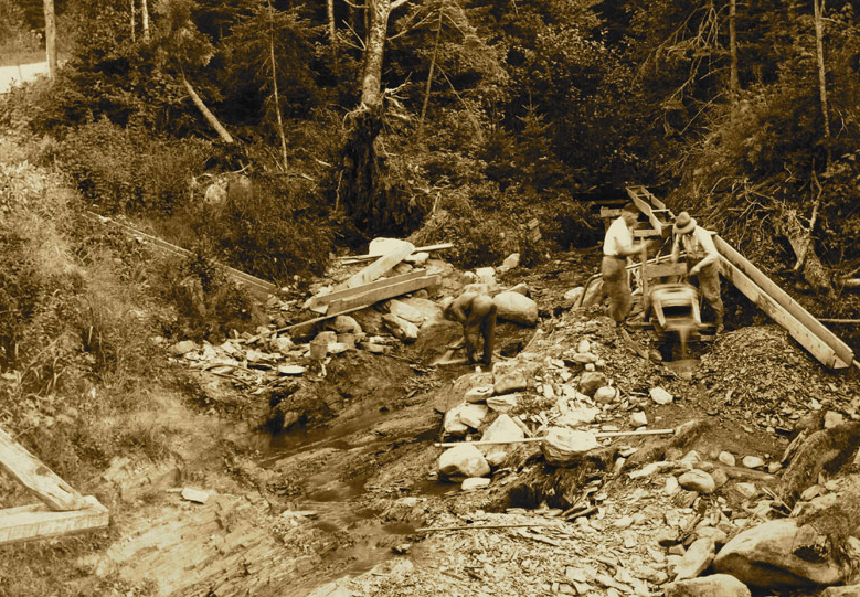
Archibauld “Archie” Annance, a pioneer placer miner, worked this district for over 30 years, recovering coarse gold from the drains, brooks, and gravels of the region using simple equipment and determination.
The Mining Brook placer district has produced over 25,000 ounces of gold historically.
Strong gold values are associated with buried channel structures beneath the Rang X area, in proximity to the current Blais and Landry gravel pits.
SECTION 4 — THE PALEOCHANNEL MODEL
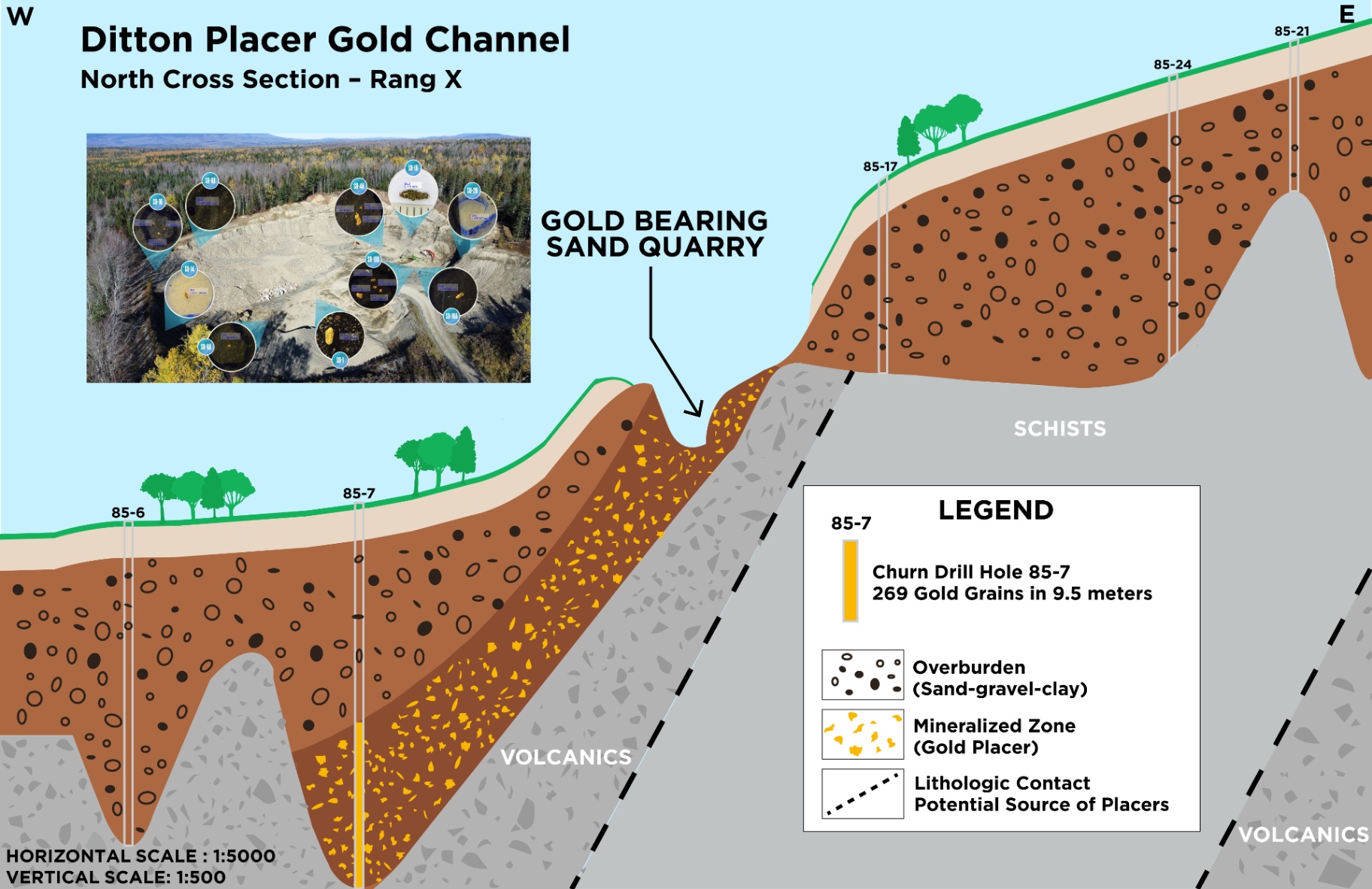
Buried Gold-Bearing Paleochannel
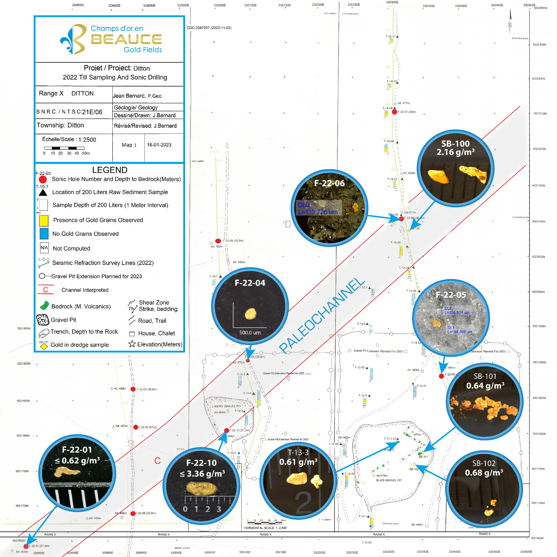
Modern seismic refraction surveys and sonic drilling confirmed the presence of buried depressions interpreted as paleochannels beneath the Rang X area.
The interpreted paleochannel:
- Trends NE-SW
- Appears open in multiple directions
- Contains both tertiary and quaternary sediments
- May extend for several kilometers
The geological setting suggests preservation of ancient auriferous gravels beneath younger glacial cover.
SECTION 5 — EXPLORATION RESULTS
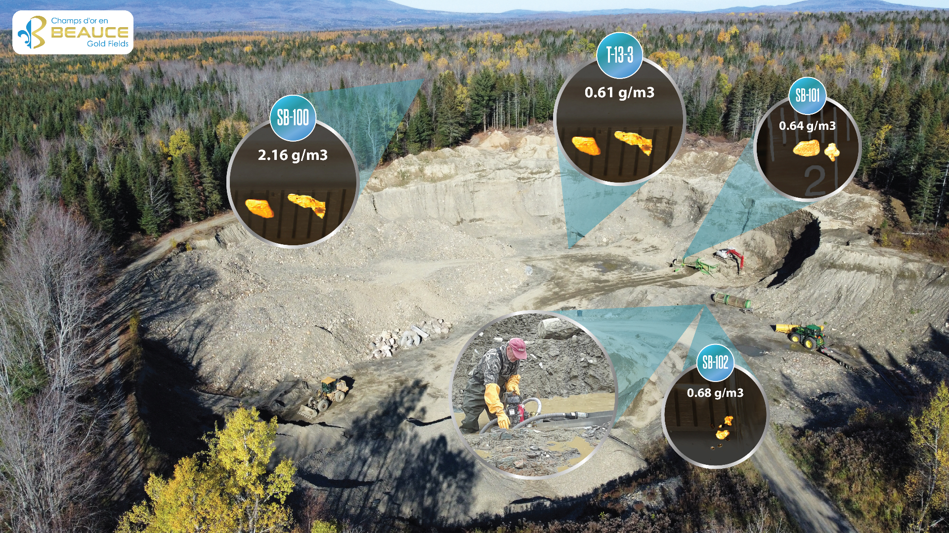
Exploration Highlights
2022–2023 Program
- 10 Sonic Drill Holes
- 180 Bulk Samples
- 4 Seismic Refraction Lines
- Over 150 sediment samples processed
- Large-volume 210 L samples
- Gravity concentration testing
Key Results
- Gold recovered from numerous samples
- Coarse gold grains and nuggets identified
- Gold in both tertiary and quaternary sediments
- Paleochannel remains open
- Indications of nearby bedrock source mineralization
2022 Till sampling & sonic drilling map
SECTION 6 — BULK SAMPLING & RECOVERY
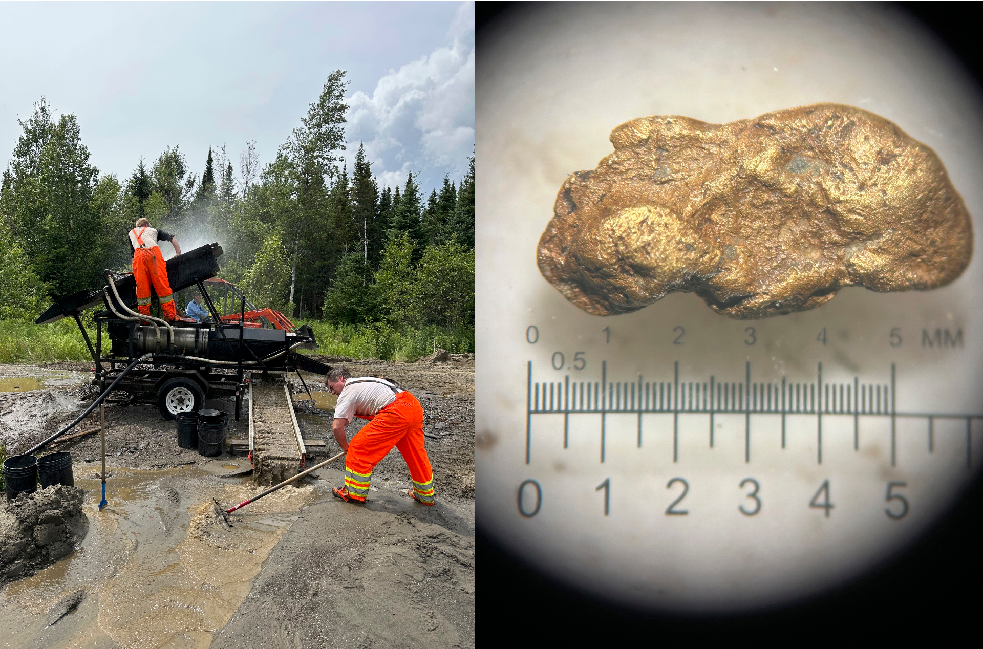
Bulk Sampling Demonstrates Gold Concentration Potential
Large-scale bulk sampling conducted at the Ditton quarry processed quaternary and tertiary gravels using gravity concentration methods.
Highlights
- 5 mm gold nugget recovered
- High-grade black sand concentrates
- Up to 154.98 g/t gold concentrate
- Gold encapsulated in pyrite identified
- Gravity-only recovery methods tested
Important Investor Message
Potential placer production concepts would rely primarily on:
- Gravity separation
- Water
- Mechanical processing
No cyanide leaching or chemical extraction contemplated in the placer recovery model.
SECTION 7 — GOLD GRAINS & SILVER SIGNATURE
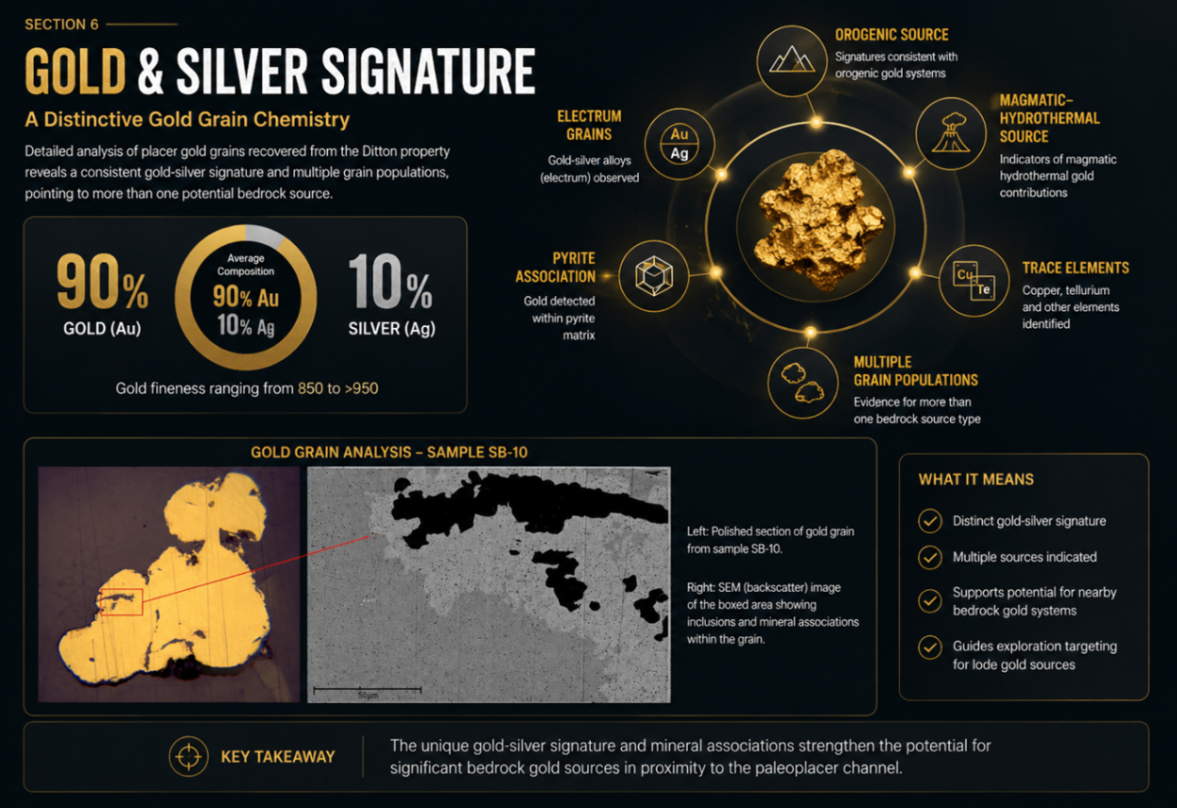
Gold-Silver Signature
Detailed gold grain studies revealed:
- Average composition of approximately 90% gold and 10% silver
- Gold fineness ranging from 850 to >950
- Multiple gold grain populations
- Possible evidence for more than one bedrock source type
The studies also identified:
- Electrum grains
- Silver-rich gold
- Copper and tellurium associations
- Possible orogenic and magmatic-hydrothermal signatures
SECTION 8 — BEDROCK SOURCE POTENTIAL
Potential Bedrock Gold Source
Gold grain chemistry and regional geology suggest that the placer gold may have originated from nearby bedrock mineralized systems. The Bella Fault corridor is considered highly prospective due to the following factors:
Structural complexity
Faulting and deformation create pathways for mineralizing fluids.
Intrusive activity
Nearby intrusions provide heat and metal sources.
Volcano-sedimentary contacts
Reactive lithological boundaries favour gold deposition.
Historic placer dispersal trails
Gold trails point back toward upstream bedrock sources.
Regional tectonic setting
Located within a known gold-bearing tectonic belt.
The property remains largely underexplored for hard-rock gold targets.
SECTION 9 — EMBERTON TARGET
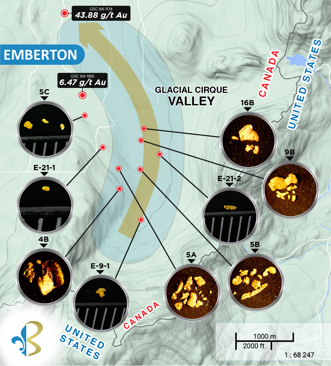
Emberton Area — Large Gold Grain Discovery Trend
The Emberton sector has identified:
- Gold over a 4 km dispersal trail
- Large gold grains
- Minimal modern exploration
This area represents an additional exploration target.
From Historic Gold Rush to Modern Discovery
Placer gold was first recovered at Mining Brook in the 1800s. Today, Beauce Gold Fields is re-evaluating the Ditton paleochannel with sonic drilling, geophysics and modern bulk-sampling — connecting historic workings to a new, scientifically backed discovery story.