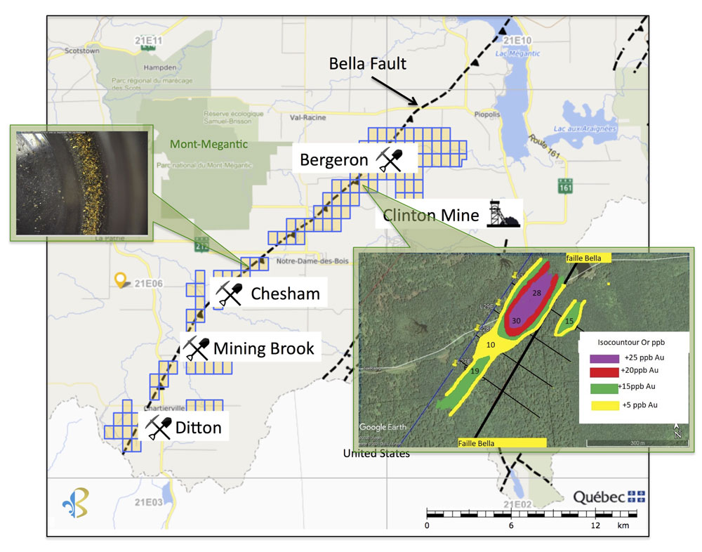
Beauce Gold Fields (Champs D’Or en Beauce) (TSX Venture: ¨BGF¨), (“BGF”), is pleased to announce the results of its soil sampling survey completed on the Bergeron section of its Megantic placer to hardrock exploration property located in southern Quebec. The survey revealed an overburden gold anomaly along strike the Bella Fault line.
Patrick Levasseur, President and CEO of Beauce Gold Fields said, “This gold anomaly, along with the Chesham 10 grams per ton sample announce last week, supports the potential of the Bella Fault line being another major gold bearing structure in Southern Quebec.” Mr. Levasseur added: “The Megantic property holds a similar geological model to the company’s flagship Saint-Simon-les-Mines Beauce Gold property whereby a major geological fault line follows along strike the historical placer gold deposit. We look forward to investigating these anomalies further later this summer.”
RESULTS BERGERON SECTOR:
The Bergeron sector forms the northern part of the Megantic property and is mostly situated on Crown land and forestry land owned by Domtar. It was first explored for placer gold deposits in 1987 (GM 45387). A large quantity of “delicate” fine gold was noted in old excavations along the Bergeron river, thus suggesting a proximal primary source. The bedrock of the Bergeron river is made up of the components of the Frontenac formation, that is to say slate schists, bands of basic metavolcanites and gabbro-dioritic sills. The property is crossed by the Bella fault in the middle trending SW to NE.
Between 1993-1995, Noranda Mines and Exploration carried out a soil geochemistry survey for zinc, copper, lead and silver on a 5km2 grid (GM 53498) Their soil sampling established copper, zinc and silver soil anomalies that appear to be continuous over significant distances. One of these anomalies is over 1.8 km in length.
Between October and December 2020, the Company collected eighty four 250g soil samples (B-horizon) for gold and silver plus base metals (Pb-Zn and Cu). 14 samples per line was collected following Noranda’s old exploration grid of six 100 metre lines (Numbered 27E to 34E). The objective was to confirm past anomalous values and to assay for new gold values (Noranda did not assay for gold). Samples were sent to Activation Labs for geochemical analysis.
Results showed a gold anomaly (+28 and +30 ppb Au) on 2 lines. This anomaly is open on both sides of the grid either SW of 27E and NE of 30E. We note that the anomaly follows along strike the Bella fault to the NW. Lines 33E and 34E showed significant anomalous zinc (33E 21 to 123 ppm Zn averaging 66 ppm, 34E 14 to 121 ppm Zn averaging 58 ppm) The Company intends to expand the soil geochemistry surveys later in the summer.
Jean Bernard, B,Sc. Geo., is a qualified person as defined by NI 43-101, has reviewed and approved the technical information presented in this release.
About the Megantic Property
The Mégantic property extends southwest to the USA border of New Hampshire and to the northeast to Lac Mégantic. The property extends for at least 30 km along the axis of the Bella Fault. It is divided into four areas: the Ditton, the Mining Brook, the Chesham and Bergeron rivers.
The Mégantic property is located at the foot of the granite intrusion of Mont Mégantic. It partly occupies the Compton Formation composed of graphitic and pelitic metasedimentary rocks of Siluro-Devonian age. These sedimentary rocks are in discordant contact in the center of the terrain with the volcanic sequence (basalts, andesites and dacites) of the Siluro-Devonian Formation of the Frontenac Formation. The Bella fault, which is the major structural element of the Mégantic property, is in contact between the Compton and Frontenac Formations.
About Beauce Gold Fields
Beauce Gold Fields is a gold exploration company focused on placer to hard rock exploration in the Beauce region of Southern Quebec. The Company’s flagship property is the St-Simon-les-Mines Gold project site of Canada’s first gold rush that pre-dates the Yukon Klondike. The Beauce region hosted some of the largest historical placer gold mines in Eastern North America that were active from 1860s to the 1960s It produced some of the largest gold nuggets in Canadian mining history (50oz to 71oz). The intent of Beauce Gold Fields is to trace the placer gold workings back to the bedrock source and uncover economic bedrock gold mineralization.
Comprising 152 contiguous claims and 7 real estate lots, the project area contains a six kilometer long placer channel consisting of unconsolidated gold-bearing auriferous units of a lower saprolite and an upper brown diamictite.
The Company has identified a major Fault Line in bedrock that coincides with geophysical findings of an interpreted fault structure across the property. Evidence suggests the erosion of the Fault Line or related fractures as a probable source of the historical placer gold channel, and has conducted bedrock sampling and geophysics outside the expression of the placer gold channel.
For further information contact
Patrick Levasseur, President and CEO Tel: (514) 262-9239
Bernard J. Tourillon, Chairman and COO Tel (514) 907-1011

Beauce Gold Fields is a gold exploration company focused on placer to hard rock exploration in the Beauce region of Southern Quebec.

