Montreal, Quebec — Beauce Gold Fields (Champs D’Or en Beauce) (TSX Venture: “BGF”), referred to as “BGF” or the “Company,” is pleased to announce that it has submitted an Application for Authorization for Impact Exploration Work (“ATI Authorization”) to Quebec’s Ministry of Natural Resources and Forests (MRNF) for drilling and related exploration activities on its Saint-Simon-les-Mines placer gold property.
The application follows a positive presentation and discussion with the municipal council of Saint-Simon-les-Mines, during which the Company outlined the results of its updated Exploration Target announced on September 3, 2025, and presented the scope of the proposed 2026 exploration work.
Patrick Levasseur, President and CEO of Beauce Gold Fields, commented: “Following the significant expansion of our Exploration Target announced in September, the ATI application represents the logical next operational step. Our objective is to systematically test the highest-priority deltaic zones identified in the updated model and continue refining the geological framework of the paleoplacer channel.” Mr. Levasseur further stated, “The strong reception from the Saint-Simon-les-Mines municipal council reflects the historical importance of gold in the Beauce region and the Company’s commitment to responsible and transparent exploration practices.”
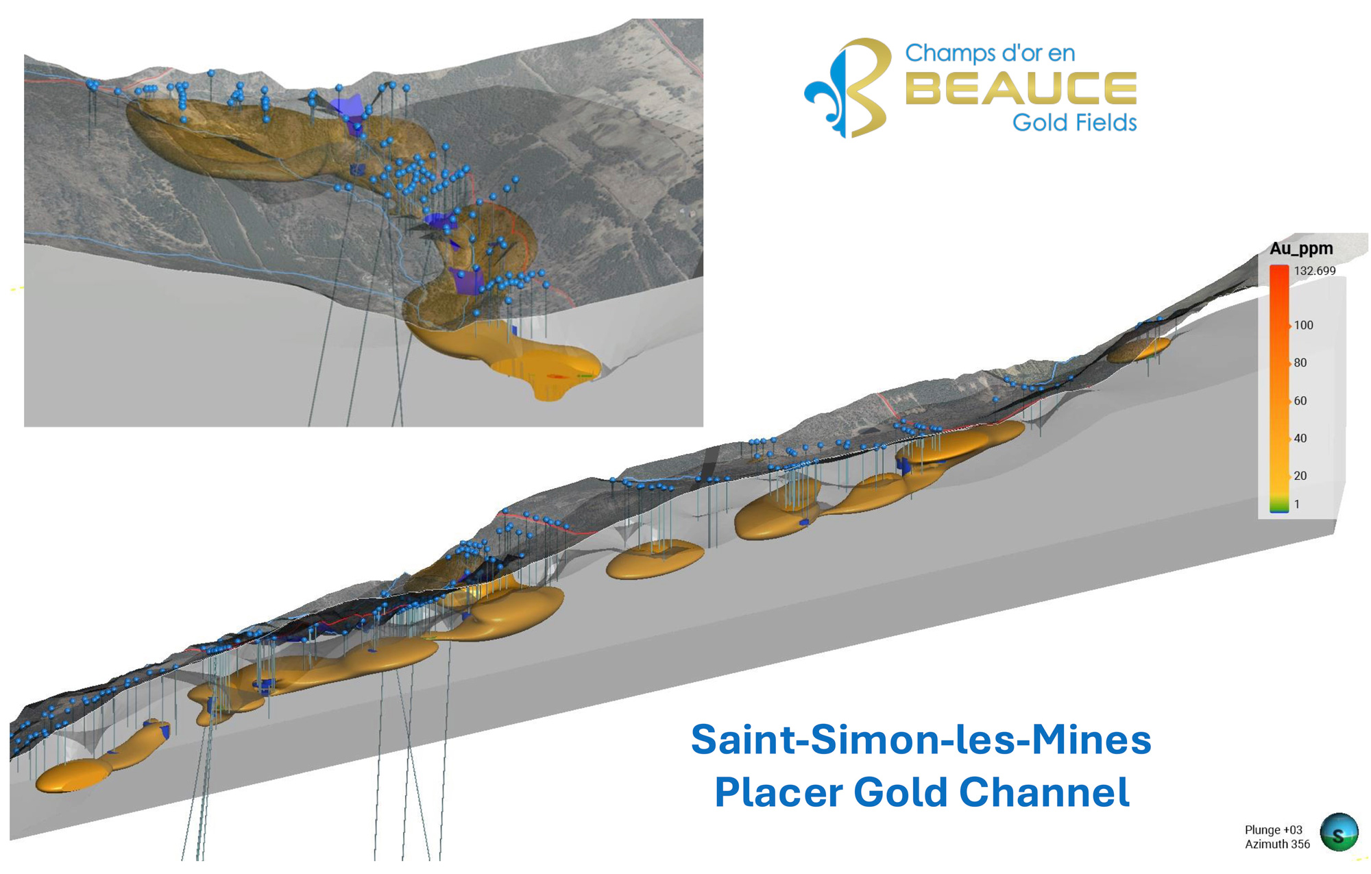
Image: 3D view of the placer gold channel, inset, cross-section at Rang Chaussegros
The planned program is designed as a follow-up to the expanded Exploration Target defined in the September 3, 2025 technical report, which outlined a conceptual Exploration Target ranging from:
3.86 million m³ @ 0.81 g Au/m³ to
3.86 million m³ @ 4.9 g Au/m³ (including nugget effect).
The Exploration Target mentioned is conceptual in nature. There has been insufficient exploration to define a mineral resource, and there can be no assurance that further exploration will result in the definition of such a resource.
The Exploration Target is based on a polygonal-based geological model that integrates historical drilling data from Beauce Placer Co. (1958–1960), Coniagas Resources (1985), Ressources Macamic (1987–88), and Beauce Gold Fields’ 2021 sonic drilling program. The model also incorporates high-resolution LiDAR-derived paleo-valley reconstructions and stratigraphic reinterpretation of auriferous units, including a saprolitic bedrock horizon and an overlying glacial diamicton enriched in coarse gold. Over 344 original historical drill logs and cross sections were georeferenced and used to refine exploration polygons and volume estimates.
The 2026 program, subject to ATI approval, is expected to include:
- Sonic drilling of high-priority deltaic polygons identified in the updated polygonal model;
- Additional delineation drilling to validate historical data integrated into the 2025 reinterpretation;
- Geophysical seismic refraction surveys to better define the bedrock topography beneath the overburden;
- Continued geological and sedimentological characterization of auriferous horizons within the paleochannel system.
The objective of this work is to further test and refine the conceptual Exploration Target and improve geological understanding of the Saint-Simon-les-Mines paleoplacer channel.
Geological Context
The Saint-Simon-les-Mines paleoplacer channel represents the core of Canada’s first gold rush district. Historical mining from the 1860s through the 1960s recovered significant coarse gold, including multi-ounce nuggets.
BGF’s updated 3-D geological modelling integrates:
- Recovered 1958–1960 Beauce Placer churn drill logs;
- Historical 1980s drilling by Coniagas, Macamic and Geological Survey of Canada;
- BGF’s 2021 sonic drilling;
- High-resolution LiDAR paleo-valley reconstruction;
- Stratigraphic reinterpretation of saprolitic bedrock and overlying diamicton units.
The upcoming drill program aims to validate and refine this integrated geological model of the Saint-Simon-les-Mines paleoplacer channel. Results will be reported as they become available.
Jean Bernard, BSc, Geo, a qualified independent person as defined by National Instrument 43-101, has reviewed and approved the technical content of this release.

Beauce Gold Fields is a gold exploration company focused on placer to hard rock exploration in the Beauce region of Southern Quebec.