Montreal, Quebec — Beauce Gold Fields (Champs D’Or en Beauce) (TSXV: ¨BGF¨), (“BGF”): (“BGF” or the “Company”), referred to as “BGF” or the “Company,” is pleased to announce the results of a geophysical survey conducted on its Beauce Gold property, located in the Beauce region of southern Quebec. The survey successfully identified the signature of a crest of an anticline fold (Saddle Reef type) coinciding with the Grondin gold zone and extended the structure along strike for 8 km. Cumulative exploration data indicates that Saddle Reef type formations are the likely bedrock sources of the Company’s historical placer gold deposits.
Patrick Levasseur, President and CEO, of Beauce Gold Fields, stated, “The identification of this anticline axis over an 8 km strike is a major milestone in our exploration of the Beauce Gold property. Those folds play a key role in the area’s gold mineralization, and these results will guide our future drilling efforts. The successful detection of anomalies matching the known Grondin gold zone increases our confidence in uncovering additional mineralized targets.”

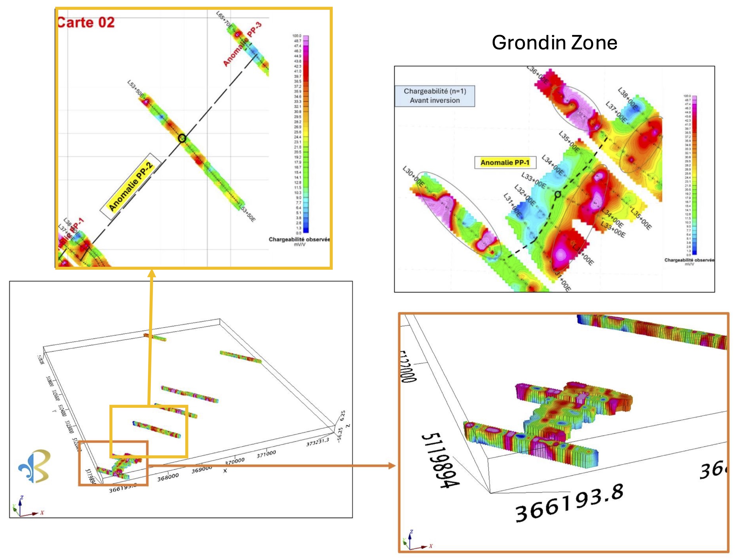
Image: IP Anomaly L36 to L65 (inset top) Grondin Zone IP (inset bottom)
The Company completed a two-phase Induced Polarization (IP) geophysical survey that successfully identified signatures aligning with the Grondin convex structure along its southwest to northeast strike over a distance of 8 km. The survey, carried out by Géosig Inc., a Quebec-based geophysics firm, involved survey lines using dipole-dipole configurations to detect subsurface resistivity and chargeability. As the region is often covered with glacial deposits of varying thickness, the IP survey allowed for the detection of geological units, stockworks and sulfides presence within the rocks.
The first phase of the survey involved a grid of 8 lines (L30E to L38E) totaling 4.2 km on the Grondin gold showing to characterize its geophysical signature. The Grondin gold mineralized outcrop and anticline structure (Saddle Reef type) were initially identified through drilling in 2023 (refer to BGF press releases from 2023-11-01, 2024-01-18, and 2024-03-20). The survey results correlated with drilled mineralized zones, confirming the presence of multiple high-chargeability and resistivity zones indicative stockworks and sulfide-rich rocks often associated with gold mineralization. A 3D model was created to determine the dip and direction of mineralized stockworks in the felsic lapilli tuff within the fold hinge.
The second phase involved cutting four additional lines to the northeast of the Grondin grid. These lines, spaced several hundred meters apart and located approximately 8 km between Boulevard Industriel in Beauceville and Chemin de la Grande Ligne in Saint-Benjamin. Positioned along trails or roads to cross perpendicularly to anticline fold axes, these lines were designed to intersect the northeastern extension of the Grondin gold zone. The results confirmed multiple high-chargeability-resistivity zones, indicative of stockwork-sulfide-rich rocks associated with gold mineralization. The field mapping survey also identified features from historical geological studies. Each survey line indicated IP anomalies corresponding to geological features of saddle reef type structure. (refer to BGF press release from 2024-07-17)
The Géosig survey identified the extension of the mineralized zone on the Grondin showing and generated several targets, which are now being investigated through field prospecting. The Company completed 225 geochemical soil samples and collected 35 rock samples over the IP anomalies of the four northeastern lines (L53E, L65E, L76E & L109E) and line L30E. The samples, each weighing 500 grams, were sent to MSALABS for assay analysis. Previous soil sampling results have correlated well with the lithology of the Grondin Zone mineralized structure. Geochemical soil sampling identified anomalous elements associated with the mineralized gold zones of the Grondin gold showing. (refer to BGF press release from 2024-04-25)
According to information obtained from the Ministère des ressources et des forêt du Québec (SIGEOM), there are 4 other axes of antiform folds located to the north of the geophysical survey and which cross the BGF claims. One of these structures is known to contain gold mineralization. It passes at the level of line 109E. Further information from laser optical remote sensing (LIDAR) allows us to interpret structures favorable to gold mineralization on the property. This data suggests that there are other sources to the north of Saint-Simon-les-Mines which would have fed the gold placers.
The combined IP data, geochemical results, and structural data will guide the selection of drill hole targets for a follow-up drilling program. This information will also enable the Company to file the necessary “Autorisation pour travaux à impact” (ATI) with the Quebec Ministry of Natural Resources for drilling authorization.
Jean Bernard, BSc. Geo., a qualified independent person as defined by NI 43-101, has reviewed and approved the technical information presented in this release.

Beauce Gold Fields is a gold exploration company focused on placer to hard rock exploration in the Beauce region of Southern Quebec.
