Montreal, Quebec — Beauce Gold Fields (Champs D’Or en Beauce) (TSX Venture: “BGF”), referred to as “BGF” or the “Company,” is pleased to announce that it has received Authorization for Impact Exploration Work (“ATI Authorization”) from Québec’s Ministry of Natural Resources and Forests (“MRNF”) for its planned 2026 exploration program at the Saint-Simon-les-Mines placer gold project.
The ATI authorizations (ATI-703 and ATI-704) allow the Company to conduct sonic drilling and seismic refraction geophysical surveys within defined exploration polygons of the paleoplacer channel. The authorizations are valid for a period of two years, until April 21, 2028
Patrick Levasseur, President and CEO of Beauce Gold Fields, commented:
“The receipt of the ATI authorizations marks an important step forward for our 2026 exploration program. With these approvals in place, we can now proceed with sonic drilling and geophysical surveys designed to validate and refine our Exploration Target and improve our understanding of the paleoplacer channel geometry and gold distribution. This program represents the next step in systematically advancing one of the most significant historical placer gold systems in Eastern North America.”
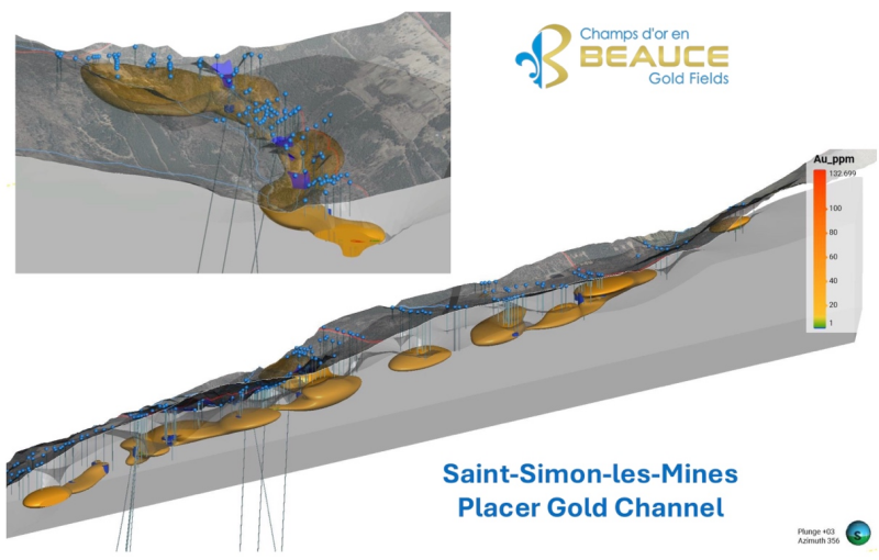
Image: 3D view of the placer gold channel, inset, cross-section at Rang Chaussegros
Exploration Target Context
The authorized work is designed as a follow-up to the Company’s updated Exploration Target for the Saint-Simon-les-Mines paleoplacer channel defined in the September 3, 2025 technical report, which outlines a range of:
3.86 million m³ @ 0.81 g Au/m³ to 4.9 g Au/m³ (including nugget effect).
The Exploration Target is conceptual in nature. There has been insufficient exploration to define a mineral resource, and there can be no assurance that further exploration will result in the definition of such a resource.
The authorized work supports the Company’s strategy to further evaluate the Saint-Simon-les-Mines paleoplacer channel, including:
- Sonic drilling of high-priority deltaic polygons identified in the updated polygonal model;
- Additional delineation drilling to validate historical data integrated into the 2025 reinterpretation;
- Geophysical seismic refraction surveys to better define the bedrock topography beneath the overburden;
- Continued geological and sedimentological characterization of auriferous horizons within the paleochannel system.
The objective of this work is to further test and refine the conceptual Exploration Target and improve geological understanding of the Saint-Simon-les-Mines paleoplacer channel.
The Saint-Simon-les-Mines paleoplacer channel represents the core of Canada’s first gold rush district. Historical mining from the 1860s through the 1960s recovered significant coarse gold, including multi-ounce nuggets.
Jean Bernard, BSc, Geo, a qualified independent person as defined by National Instrument 43-101, has reviewed and approved the technical content of this release.

Beauce Gold Fields is a gold exploration company focused on placer to hard rock exploration in the Beauce region of Southern Quebec.