Montreal, Quebec — Beauce Gold Fields (Champs D’Or en Beauce) (TSXV: ¨BGF¨), (“BGF”): (“BGF” or the “Company”): referred to as “BGF” or the “Company,” is pleased to announce results from diamond drill core analyses from the Grondin gold zone. Intersections have indicated a silver/gold ratio of 23.68% and contains significant levels in certain elements, notably arsenic, antimony, bismuth, and tungsten. These same elements have been well identified in significant quantities within an auriferous till directly associated with gold-bearing placers and buried in the valley of the Gilbert River, located at Saint-Simon-les-Mines, Quebec.
Patrick Levasseur, president and CEO of Beauce Gold Fields, stated: “This strong correlation for these pathfinder elements, as well as the silver/gold ratio suggests a local source. The source of these indicator elements would come from mineralized structures like those recently found at the Grondin site. These mineralized zones have been eroded from antiforms (Saddle Reef) that extend parallel to the northwest of the placer deposit.” Mr. Levasseur also declared: “This marks another significant step, one that will guide our exploration work towards the possibility of discovering an economically viable gold deposit.”
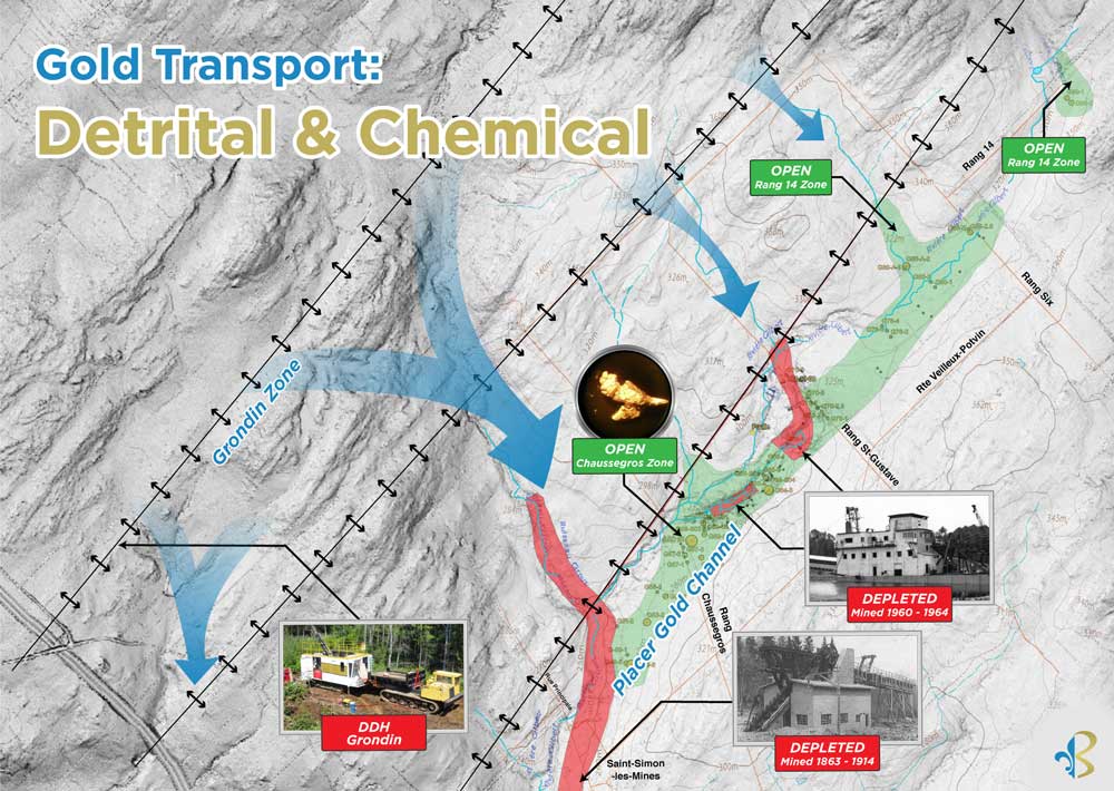
Gold Transportation from Bedrock to Placer Channel
Matching Pathfinders Elements
On November 1, 2023, the Company released the results of an eight holes diamond drill program totaling 501 meters that were performed on the site of the Grondin outcrop. It is located on the Beauce Gold property near the municipality of Beauceville, Quebec. Drill hole GR 23-01 crossed various gold-mineralized zones over its entire length of 36 meters. This drilling intersected three gold zones that are comprised between 11 and 36 meters. They have been selected to be assayed for 35 elements (MSALABS Multielement ICP-AES\MS). All these zones are associated with networks of quartz veins (stockworks) more or less rich in sulfides. Analysis results for these three zones have indicated high levels in arsenic (As), with an average of 951 ppm, followed by antimony (Sb) with 2.22 ppm, bismuth (Bi) with 0.25 ppm, and finally tungsten (W) with a content of 20 ppm.
In 2011, Uragold conducted a sonic drill campaign in the basal till and in the saprolite of the placer gold channel, which yielded numerous visible gold grains. The analysis of the heavy mineral concentrate recovered from the basal till returned arsenic (As) with an average of 59 ppm, antimony (Sb) with 2.08 ppm, bismuth (Bi) with 0.19 ppm, and tungsten (W) with 78 ppm. All these tracer elements strongly suggest a local source located north of the Gilbert River. (Source: Sedar: Report 43-101 – Beauce July 4, 2018, Author B. Violette)
Drill hole GR 23-01 Gold and Pathfinder Elements
| Au ppm | Ag ppm | As ppm | Bi ppm | sb ppm | w ppm | |
| Cor0247004 | 1.5 | 0.36 | 468 | 0.12 | 1.5 | 22.5 |
| Cor0247005 | 2.4 | 0.44 | 752 | 0.12 | 1.3 | 15.2 |
| Cor0247006 | 2.6 | 0.57 | 2754 | 0.09 | 2.3 | 13.3 |
| Cor0247007 | 1.5 | 0.35 | 1546 | 0.04 | 1.2 | 27.3 |
| Cor0247015 | 2.4 | 0.76 | 638 | 0.28 | 2 | 18 |
| Cor0247016 | 3 | 0.79 | 706 | 0.36 | 3.2 | 21.4 |
| Cor0247017 | 2.9 | 0.66 | 974 | 0.24 | 3.9 | 22.8 |
| Cor0247018 | 6.3 | 1.63 | 1696 | 0.62 | 5 | 20.2 |
| Cor0247019 | 11.4 | 1.77 | 350 | 0.47 | 2.5 | 41.3 |
| Cor0247029 | 1.7 | 0.85 | 340 | 0.26 | 0.9 | 12.5 |
| Cor0247030 | 1 | 0.51 | 242 | 0.2 | 0.7 | 4.5 |
Silver to Gold Ratio
All three gold zone intersects from drill hole GR 23-01 reported anomalous silver levels, averaging 0.79 ppm. By consolidating the silver content with the gold zone intersects, which averaged at 3.33 g/t of gold, we achieve a silver to gold ratio of 23.68%. It is assumed that electrum is present in the drill cores.
A scanning electron microscopy (SEM) analysis of the placer gold grains recovered from Uragold’s 2011 sonic drill cores indicated that the gold surfaces had an average silver content of 6%.
Historical records document silver recovery from past placer gold mining operations. Receipts from the Royal Canadian Mint for the 1960s Beauce Placer Mining dredging operation indicated an average silver to gold content of 13%. An 1863 Geological Survey of Canada report by T. Sterry Hunt recorded a silver to gold content of 12.54%.
The reduced silver content in the gold placers, compared to the Grondin cores, could be attributed in part to the dissolution of the metal during transport or to a prolonged geological period in a warmer secondary environment.
Gold Transportation from Bedrock to Placer Channel
A positive correlation applies to silver and the pathfinder elements that were identified for the Grondin zone and these same elements detected in the sediments of the gold channel of the Gilbert River. They support the hypothesis that the gold comes from the erosion of quartz veins, alteration, and dissolution of the sulfides that contain them. The gold was first trapped and deposited in the crests of the antiform folds of Saddle Reef type formations. Their axes are located northwest of the Gilbert River. The gold grains would be both of detrital origin, from the erosion of quartz veins releasing particles of gold of different sizes, and chemical origin, with coarser gold first coming from the dissolution of sulfides releasing the precious metals. Afterwards they precipitated in the form of nuggets (accretion phenomenon) in layers of fractured saprolite and/or in schistosity planes of fissile and oxidized rocks. (see BGF press release of January 17, 2023)
Jean Bernard, B,Sc. Geo., is a qualified person, as defined by NI 43-101, who has reviewed and approved the technical information presented in this release.

Beauce Gold Fields is a gold exploration company focused on placer to hard rock exploration in the Beauce region of Southern Quebec.