Montreal, Quebec — Beauce Gold Fields (Champs D’Or en Beauce) (TSXV: ¨BGF¨), (“BGF”): (“BGF” or the “Company”): referred to as “BGF” or the “Company,” is pleased to announce results of a recent drilling program of 8 diamond drill holes totaling 501 meters carried out at the Grondin gold showing on the Beauce Gold property situated in Beauceville, Quebec and has identified a promising structure which could be one of the sources which hypothetically could have supplied the historical gold placers of the Gilbert river valley located in Saint-Simon-les-Mines.
HIGHLIGHTS
- Identification of a promising structure which could be one of the sources and which hypothetically would have supplied the gold placers of Saint-Simon-les-Mines.
- A high-grade antiform fold gold structure was identified by these drillings, up to 11.4 g/t
- The Grondin mineralized zone remains open laterally and at depth. The mineralized zone extends over several hundred meters. The zone seems to draw an antiform fold structure.
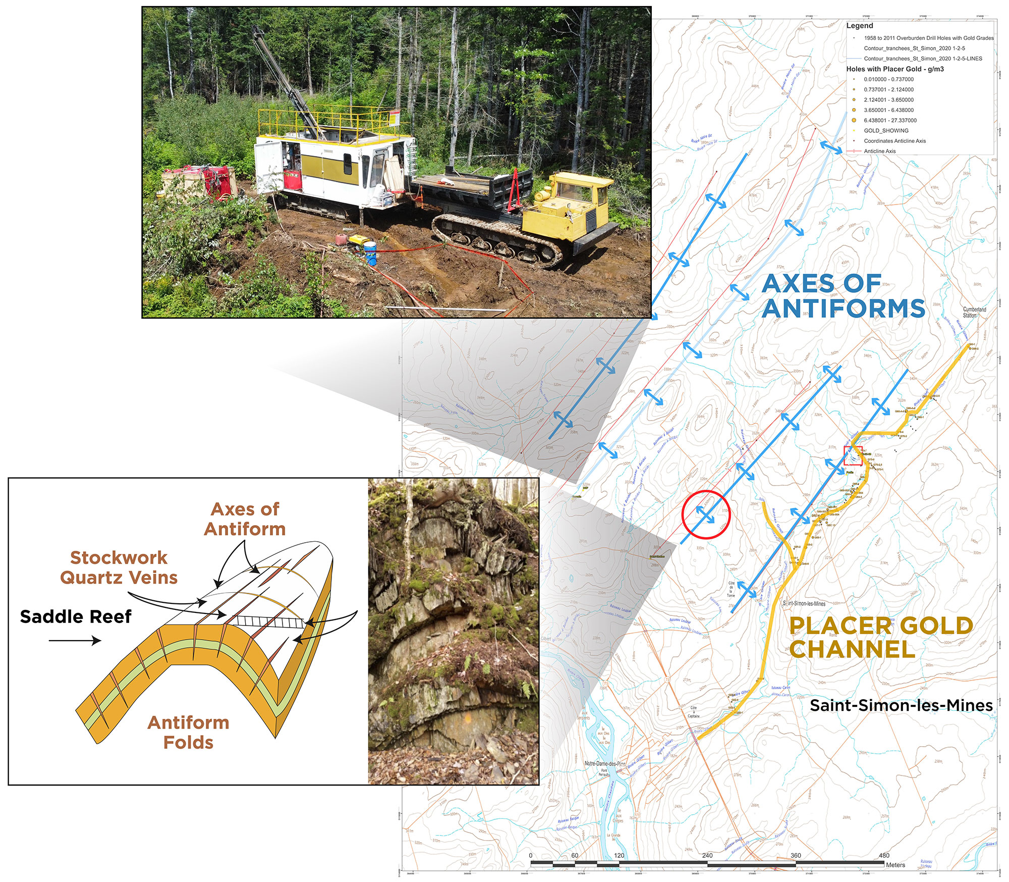
Image: Location of drilling, Antiforms and Placer Channel
Patrick Levasseur, President and CEO of Beauce Gold Fields, stated, “These drilling results have unearthed a highly promising structure that could potentially be one of the sources responsible for the historical gold placers in Saint-Simon-les-Mines. The discovery of a high-grade antiform fold gold structure, with grades of up to 11.4 g/t, is particularly exciting. The Grondin mineralized zone’s lateral and depth extensions, along with the presence of mineralized blocks, suggest significant exploration potential. Our exploration efforts are guided by the possibility of uncovering a substantial lode gold deposit, and these results are a significant step forward in that direction.”
The mineralized zone, which was intercepted by drilling, indicates that the Grondin zone measures more than 40 meters in depth vertically. This zone extends over 70 meters in width and would remain open at depth. The mineralized structure was found over 300 meters NE of the primary showing. Mineralized blocks were found on the surface SW of the main trench. This debris from the vein suggests that it remains open for hundreds of meters towards the SW and the NW. Other antiform folds cross the property, and other gold zones could be present. Axes of antiforms forming a Saddle Reef formation is the predominant geological model for potential lode gold discoveries and a possible source of the historical paleoplacer gold deposit.
Table: Mineralized Segments
| Hole No | From (m) | To (m) | Interval (m) | Au (g/t) |
| RG-23-01 | 11 | 14 | 3 | 1.7 |
| Including | 12.5 | 13.5 | 1 | 2.5 |
| And | 17.3 | 19.5 | 2.2 | 5.4 |
| Including | 18.5 | 19.5 | 1 | 8.85 |
| Including | 19 | 19.5 | 0.5 | 11.4 |
| And | 21.5 | 24 | 2.5 | 1.8 |
| RG-23-04 | 8.5 | 14.5 | 6 | 1.08 |
| Including | 12 | 14 | 2 | 1.9 |
| Including | 13 | 13.5 | 0.5 | 3.6 |
| RG-23-05 | 37.5 | 41 | 3.5 | 3 |
| Including | 38 | 39 | 1 | 6.5 |
| Including | 38 | 38.5 | 0.5 | 10.88 |
| RG-23-06 | 42.5 | 43 | 0.5 | 2.8 |
| And | 45.5 | 47.5 | 2 | 0.16 |
| RG-23-07 | 34 | 36.5 | 2.5 | 0.51 |
| Including | 35.5 | 36.5 | 1 | 0.81 |
| Including | 36 | 36.5 | 0.5 | 1.27 |
| And | 37.5 | 39 | 1.5 | 0.35 |
| And | 50 | 51 | 1 | 0.92 |
| Including | 50.5 | 51 | 0.5 | 1.6 |
| RG-23-08 | 27 | 28 | 1 | 0.31 |
| And | 48.2 | 50 | 1.8 | 1.1 |
| Including | 48.5 | 49 | 0.5 | 2.2 |
Drill hole GR 23-01 crossed the entire length of the mineralized zone over 36 meters. This drilling intersected three (3) gold zones between 11 and 24m. All areas are associated with stockworks that are more or less rich in sulphides. The mineralized zones are strongly affected by significant deformation leading to loss of the core and more precisely at the end of this drilling. This drilling intersected three zones, including a more significant one grading 5.4 g/t Au over 2.2m.
Hole GR 23-02 was implanted at the same position as GR 23-01 but with an angle of -70°. Based on surface measurements, it was interpreted that the dip of the area was towards the NW. We quickly realized that the latter had not intercepted the large zone found in the first drilling. The zone folds and returns in depth towards the SE. According to the results of drill core analyses, the mineralized zone is slightly observed in drilling RG 23-02
Hole RG 23-03 was placed a few dozen meters NW of the collars of the first two holes to verify for the rest of the program the direction of the dip of the mineralized zone. No zone of interest was found in this drilling.
Hole RG 23-04 was located to the NE of the stripped zone with the aim of verifying the extension of the zone towards this direction. A 2m zone was crossed, grading 1.9 ppm Au, including a grade of 3.6 g/t Au over 0.5m noted in this zone.
Holes GR 23-05 and 06 boreholes were oriented to form a scissor (cross cut) by reaching the depth of the first three boreholes. RG 23-05 found the main zone approximately 25 meters southeast of the RG 23-01 area and approximately 40 meters vertically below the surface. According to our interpretation, the mineralized zone grading 3 g/t Au over 3.5m would correspond to the actual thickness of that zone.
Hole RG-23-06, located in the same position as hole 5, was inclined at -80° in order to intersect the zone at greater depth. It appears that the area was partly affected by shear truncating it. A 0.5m intersection assayed 2.8 g/t Au.
Drill holes RG 23-07 and RG 23-08 tell us that the gold zone extends towards the NE of the primary showing. The grades and thicknesses are lower than other drilling that has crossed the area. The shear zones have significantly affected the strength of the mineralized zone.
Host structures. The S1 schistosity of the surrounding rock, which runs along the mineralized zone, shows a dip of -70° towards the SW. The first three drillings, however, demonstrated that the dip of the mineralized zone turns at depth from SW to NE. This area seems to draw a limb of an antiform fold. The gold zone could be dislocated and shifted by step caused by shear faults. The highest gold contents (+10 ppm Au) were associated with sulphides, particularly in a massive pyrite. Arsenopyrite would not be the primary gold source on the Grondin showing.
It should be noted that the host structures are interpreted to be steeply inclined at the surface and become subhorizontal at depth. Actual widths are unknown at this time. Multiple orientation veins transverse to primary host structures are commonly observed in drill core, which could lead to uncertainty in the actual width of the mineralized zone.
All drilling recovered HQ cores. Drill cores were split in half using a diamond saw. Half of the core was sampled and sealed in clean plastic bags before being shipped for assay. The remaining half of the core was replaced in core boxes and is stored at the Company’s core shack in Saint-Simon-les-Mines.
Standards and blanks are inserted in the sequence of samples on-site as quality assurance and quality control. Drill core samples were submitted to MSA in Val-d’Or, Quebec. MSA is an ISO-17025 accredited laboratory for the photon assay method.
Jean Bernard, B.Sc. Geo., a qualified person as defined by NI 43-101, has reviewed and approved the technical information presented in this release.
About the Grondin Zone outcrop
The Grondin outcrop reveals a substantial mineralized quartz vein stockwork of the Crack and Seal type, visible along the axis of the antiform. This axis outcrop extends 500 meters northeast along strike on the northwest portion of the Beauce Gold property. Notably, it lies approximately 3 kilometers northwest from the 19th-century placer gold mines at Giroux Creek and the Gilbert River, paralleling the historical placer gold deposit of St-Simon-les-Mine. Among the samples collected, two showed particularly high gold grades: sample 81755 at 2.11 grams/ton and sample 81763 at 10.9 grams/ton (GM 70761 Réjean Hébert, geologist, June 2018). The Company also conducted grab samples, with results ranging from 200 ppb Au to 1,400 ppb Au.

Beauce Gold Fields is a gold exploration company focused on placer to hard rock exploration in the Beauce region of Southern Quebec.