Montreal, Quebec — Beauce Gold Fields (Champs D’Or en Beauce) (TSXV: ¨BGF¨), (“BGF”): is pleased to announce that filtered geophysics data from a 2019 IP survey reveals anticline folds indicative of a saddle reef formation on the company’s Beauce Gold property located in St-Simon les Mine, Quebec.
Patrick Levasseur, President and CEO of Beauce Gold Fields said, “This IP is another exciting data set supporting a Saddle Reef Formation as a leading geological model as the source of the historical placer gold nuggets.” Mr. Levasseur added: “We look forward to further explore and sample Antiform outcrops for new drill hole targets to test the Saddle Reef Formation for lode gold discoveries.”
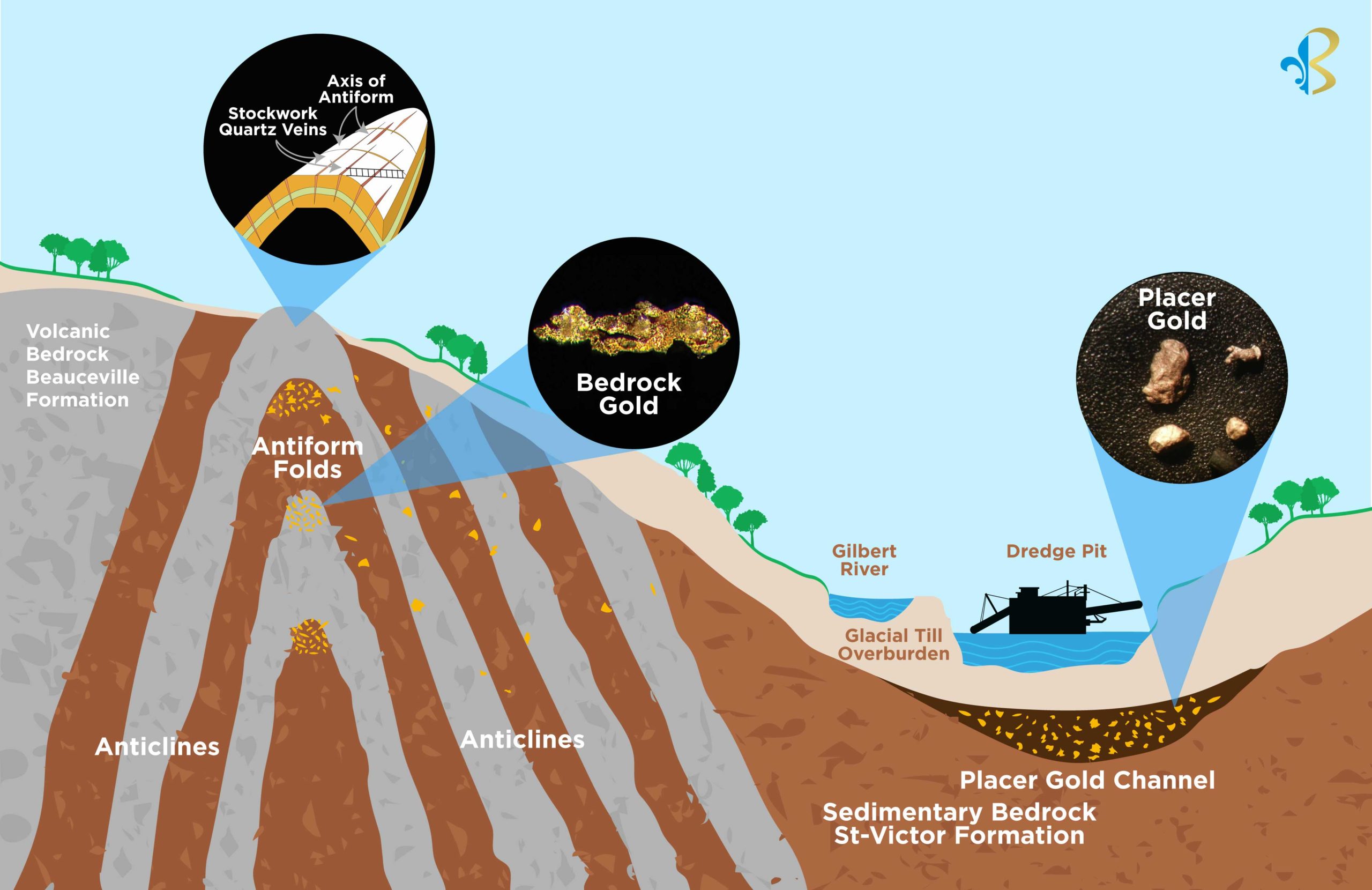
Feature Image: Cross section model of a Saddle Reef Formation on the Beauce Gold Property.
In winter of 2019, the Company carried out three 1,200 meter lines of electrical resistivity and induced polarization (IP) surveys that crossed the Gilbert River, parallel to the right and left banks of the Grioux creek (Lines 2, 4 and 5 BGF press release 2020-01-03, ). The INRS (Institut national de la recherche scientifique) enhanced the 2019 data for lines 4 and 5 by applying a noise reduction filter to the 2D inversion electrical resistivity and electrical chargeability data.
The filter could not be applied to Line 2 due to signal distortions likely caused by underground tunnels of the 19th century placer gold mines. Lines 4 & 5 filters revealed tomographic 2D images characterized by deformed structures of synform-like pleated zones suggesting the presence of Antiform structures with relatively tight vertical anticline limbs. This correlates with the structural pattern of Saddle Reef formations.
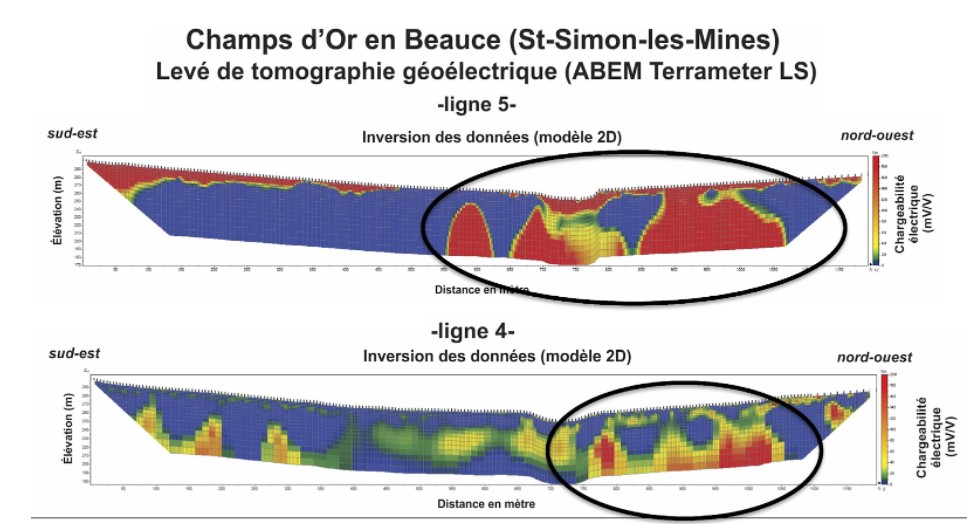
2D IP images characterized by synform – antiform structures Lines 4 & 5
The geological model of a Saddle Reef formation indicated by the IP survey is also supported by observed eroded anticline vertical limbs in the 2019-2020 trenches and by the discovery of exposed domed Axis of Antiform ridges along the Giroux creek. The Axis trends NE & SW for 4 km to the North of the Gilbert River as well as North of the historical placer gold channel (BGF press release 2021-12-21). Eroded segments of the Saddle Reef formation is the leading hypothesis as to the source of the historical placer gold deposit.
In its upcoming spring/summer exploration program, the Company will continue to trace and sample significant mineralized Crack and Seal type quartz veins stockwork outcroppings along the Axis of the Antiforms located between the Rang St-Charles to the Rang VI roads. Finding gold mineralization in Antiform outcrops will generate new drill targets to drill through axial folds of the Saddle Reef.
It is theorized that the placer gold, such as the famous large nuggets mined in the 19th century, were formed in stressed quartz pockets of the domed Axis of Antiforms as demonstrated in Saddle Reef formations. Saddle Reef examples include the huge Bendigo and Ballarat gold fields of Australia (over 60 million ounces), and the high grade Dufferin deposit in Nova Scotia.
Jean Bernard, B,Sc. Geo., is a qualified person as defined by NI 43-101 who has reviewed and approved the technical information presented in this release.

Beauce Gold Fields is a gold exploration company focused on placer to hard rock exploration in the Beauce region of Southern Quebec.