Montreal, Quebec — Beauce Gold Fields (Champs D’Or en Beauce) (TSXV: ¨BGF¨), (“BGF”): is pleased to announce results of a 38 hole diamond drill program totaling 4,585 meters to test numerous high-priority targets on the Company’s Beauce Gold property located in Saint-Simon-les-Mines, Quebec.
Drilling result highlights:
- Successfully breached major Fault Line
- Anticlines limb structures supports Saddle Reef model
- Dichotomy of visible gold to drill results confirms Nugget Effect
- New gold zone discovered
Patrick Levasseur, President and CEO of Beauce Gold Fields said, “Prior to the drill program, little was know about the bedrock geology surrounding the placer gold channel.” Mr. Levasseur added: “The drill data provides us an unprecedented overview leading us to a Saddle Reef Formation as a leading geological model as to the source of the historical placer gold nuggets.”
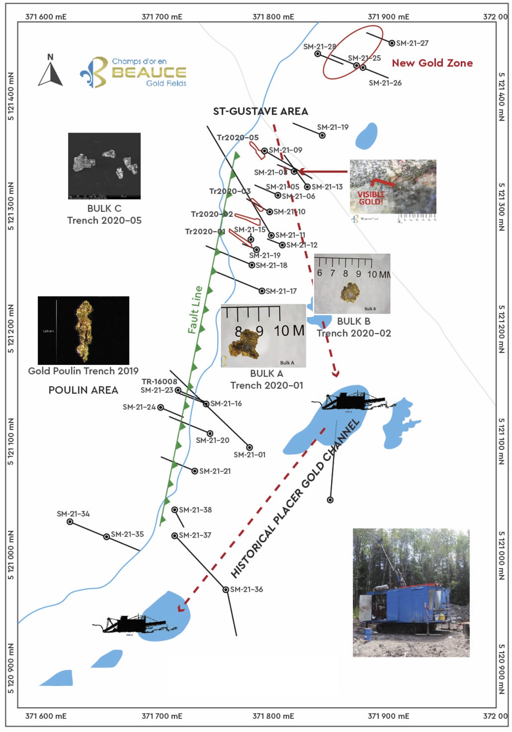
Fault Line Confirmed
The drill holes that clearly showed the presence of the major fault line that strikes SW-NE across the property are holes SM-21-01, SM-21-03 and SM-21-21. The drill core sections that breached the fault line encountered over 10 meters of crumbled or pulverized rock and breccias. Thrust movements at the Fault line crushed the mostly black shale rock resulting in poor drill core recovery. The Fault segment in Hole SM-21-21 is also in alignment with a surface topographical break observed on the Gilbert River.
The Fault was first identified by INRS in 2017 using AMT geophysics and observed in Poulin Trench 10008. It runs parallel to the NW side of the historical placer gold channel. The Fault is interpreted as the leading geological structure in the placer valley and the contact point of folding bedrock that caused multiple Anticline folds.
Anticline Structures Confirmed:
A series of drill holes were completed on the St-Gustave section of the property to test at depth vertical limbs of anticline bedding as well as to test gold bearing mineralized structures first observed in Trenches in 2020. The zones strike N30E and the hinge zone goes from -80NW to -80SE. Drill cores from holes SM-21-03 and Holes SM-21-05 to SM-21-19 on the St-Gustave crossed sub-vertical limbs of interbedded bands of black shales – siltstones (Sedimentary Rocks) and tuffs – LapiIllis (Volcanics Rocks) interspaced with quarts veins.
Eroded anticline vertical limbs observed in the trenches and antiform structures discovered on the Beauce Gold property supports a Saddle Reef formation as the leading geological model going forward for gold mineralization and exploration. (BGF press release 2021-12-21). Saddle Reef examples include the huge Bendigo and Ballarat gold fields of Australia (over 60 million ounces), and the high grade Dufferin deposit in Nova Scotia.
FEATURE IMAGE: Map Drill Holes SM-2021.
Nugget Effect: Dichotomy of Visible Gold versus Drill Results
The objective of the Poulin drill holes (SM-21-1,16,22,23) and St-Gustave drill holes (SM-21-5 to 19) was to test gold bearing mineralized structures. In 2019 and 2020, the company completed an extensive series of trenches to expose and sample bedrock. The Trench work by Marc Richer Lafleche PhD Geo., of INRS identified the presence of visible gold in the St-Gustave trenches TR-2020-01 (Bulk A), TR-2020-02 (Bulk B) TR-2020-05 (Bulk C) as well as a gold grain in Poulin trench 10008. (BGF press releases January 1, 2019 and May 12, 2021). The gold mineralization was mainly found in blue-gray quartz veins at the contact between lapilli tuffs and black shales. Mineralization is also found in stockwork hydrothermal breccias zones in both units.
Drill results from the Poulin and St-Gustave sectors confirmed a dichotomy between visible gold observed in the mineralized sections of the trenches and drill hole SM-21-08 versus all the drill holes from these two sectors that returned almost no gold. Grains of gold up to 3mm were extracted from 68kg bedrock rock samples taken from the trenches yet the drill cores aligned to corresponding anticline limb structures at depth, returned no gold values. Drill core segment 34-34.5m of drill hole SM-21-08, best demonstrates this striking nugget effect. One half of the split drill core contained 2 visible gold grains measuring between approximately 250 and 350 microns (0.25 to 0.35 mm) embedded in folded-boudinage blue-gray quartz- vein yet the other half core sent to be assayed returned no detectable gold. The Company emphasizes that while this drill program was useful for identifying mineralized structures, it was not a reliable indicator of gold grade for these sectors. Greater core volume or bulk sampling will be required to quantify true gold grade analysis.
The high nugget effect affecting gold distribution in the bedrock structure is analogous to the coarse gold and the well documented large gold nuggets reported from the historical placer gold channel. The Company hypothesizes that greater concentrations of coarse gold and nuggets are to be discovered in quartz vein pockets of hydrothermal breccias in domes of Antiform Folds within Saddle Reef formations.
St-Gustave Section – New Gold Zone
Anomalous gold results of up to 145 ppb Au from Drill holes SM-21-25, SM-21-27 and SM-21-28 drilled below tunneling found on the property from the St-Gustave placer gold mine operated by Champs-D’Or Rigaud-Vaudreuil company in the 1910s. Results point to a new gold zone approximately 150 meters NE of hole SM-21-08. The anomaly was from core segments of blue quartz veins similar to the blue gray quartz containing visible gold in hole SM-21-08. The holes intersected a stockwork zone beneath an outcropping Anticline structure northeast of Rang Saint-Gustave near the Gilbert River.
Historical Placer Gold Channel:
Six boreholes (SM-21-2, 4, 36, 37 and 38) were drilled to test structures below sections of high grade placer gold from segments of the historical placer channel that was mined by a dredging operation in the 1960s. Another four drill holes (SM-21-30 to SM-21-34) were targeted to intersect the rocks under high placer gold grades recorded by historical overburden drilling in the gravels of a small tributary of the Gilbert River (Section G-80-A, 3.65g/m3 Au, 1987 GM46544).
The drill holes passed through lithologic units that do not match those beneficial for containing gold. The rocks underlying the gold placers are mainly composed of graphitic sedimentary rocks that returned no gold values. Black shales sometimes contain up to 15-20% authigenic but sterile pyrite.
This supports the theses that the origin of the gold placers is from eroded Antifold structures that parallels to the NW the historical placer gold channel.
Quality & Control
The drilling program and the interpretation of results are under the control of BGF’s geological team, which includes strict protocols in accordance with NI 43-101 and industry best practices. Sampling and assay results from drill cores are subject to a quality assurance and quality control (QA-QC) program. Drill cores (NQ-HQ sizes) are outlined and samples are selected by the geologist and then cut in half using a diamond blade saw at the project site. One half of the core is kept at the site for reference purposes. The length of the sampling intervals can vary between 0.5 and 1.5 meters, depending on geological observations. Core halves are packaged and transported in sealed bags and mailed to the Actlabs laboratory in Ancaster, Ontario. This laboratory (ISO 17025 certification) analyzed all rock and core samples from the drilling program using a fire test and atomic absorption finish for gold and gravimetric finish if gold grades exceeded 3g /t Au. As part of the sampling sequence, duplicate, blanks and certified reference materials are inserted for all boreholes for quality control purposes. Mr. Jean Bernard, geologist, exploration manager for the Company and a QP as defined in NI 43-101 for the Saint-Simon project, supervised the QA/QC program of the Company.
Jean Bernard, B,Sc. Geo., is a qualified person as defined by NI 43-101 who has reviewed and approved the technical information presented in this release.
| Hole No | Depth | From | To | Intervalle | Au | Sector |
| (m) | (m) | (m) | (m) | (ppb) | ||
| SM-21-01 | 288 | 155 | 157 | 2 | Poulin (TR-10008) | |
| SM-21-02 | 192 | Channel (10SW-750L: 0,181 g Au/m3) | ||||
| SM-21-03 | 300 | 52 | 55 | 3 | Saint-Gustave (TR2020-02-TR2020-46) | |
| SM-21-04 | 147 | Channel (3SW-400L: 0,07g Au /m3) | ||||
| SM-21-05 | 69 | 25 | 26.5 | 1.5 | Saint-Gustave (TR 2020-03) | |
| SM-21-05 | 29 | 33.5 | 4.5 | Saint-Gustave (TR 2020-03) | ||
| SM-21-06 | 81 | 20 | 22 | 2 | Saint-Gustave (TR 2020-03) | |
| SM-21-07 | 54.2 | Saint-Gustave (TR2020-05) | ||||
| SM-21-08 | 64.8 | 26 | 27 | 1 | 350 | Saint-Gustave (TR2020-05) |
| SM-21-08 | 34 | 34.5 | 0.5 | Visible Gold | ||
| SM-21-09 | 150 | Saint-Gustave (TR2020-05) | ||||
| SM-21-10 | 97 | Saint-Gustave (TR2020-04) | ||||
| SM-21-11 | 66 | Saint-Gustave (TR 2020-03) | ||||
| SM-21-12 | 75 | 20.5 | 22 | 1.5 | Saint-Gustave (TR 2020-03) | |
| SM-21-13 | 150 | 51.5 | 54 | 2.5 | 55 | Saint-Gustave (Ext SM-21-08) |
| SM-21-14 | 74 | 53 | 54 | 1 | Saint-Gustave (TR 2020-04) | |
| SM-21-15 | 102 | 23.5 | 24.5 | 1 | Saint-Gustave (TR2020-01) | |
| SM-21-16 | 84 | Poulin (TR-10008) | ||||
| SM-21-17 | 150 | Saint-Gustave (TR2020-01) | ||||
| SM-21-18 | 145 | 38 | 39 | 1 | 37 | Saint-Gustave (TR2020-01) |
| SM-21-19 | 75 | Saint-Gustave (TR2020-01) | ||||
| SM-21-20 | 171 | 89.5 | 90.5 | 1 | Poulin (TR-10008) | |
| SM-21-21 | 117 | Poulin (TR-10008) | ||||
| SM-21-22 | 81 | 80.5 | 81 | 0.5 | Poulin (TR-10008) | |
| SM-21-23 | 72 | 12 | 14 | 2 | Poulin (TR-10008) | |
| SM-21-24 | 75 | Poulin (TR-10008) | ||||
| SM-21-25 | 93 | 57 | 59 | 2 | 42.5 | Saint-Gustave (Ext SM-21-08) |
| SM-21-25 | 61.5 | 63 | 1.5 | 38.6 | Saint-Gustave (Ext SM-21-08) | |
| SM-21-26 | 90 | 14 | 15 | 1 | Saint-Gustave (Ext SM-21-08) | |
| SM-21-27 | 96 | 51 | 52 | 1 | 124.5 | Saint-Gustave (Ext SM-21-08) |
| SM-21-27 | 57.5 | 58 | 0.5 | 145 | Saint-Gustave (Ext SM-21-08) |
Beauce Gold property Spring Summer Exploration 2022
- Mapping and sampling the Ruisseau Giroux sector (site of 19th century placer mines & the +50 ounce historical gold nuggets)
- Identify & Map Antiform outcrops from Rang St-Charles to Rang 6
- Trench and bulk sample for high grade gold along Axis of Antiforms
- Pending sample results, plan drill campaign to drill the Axial Planes of Anticlines Folds as well as the test drilling the Ruisseau Giroux sector

Beauce Gold Fields is a gold exploration company focused on placer to hard rock exploration in the Beauce region of Southern Quebec.