Montreal, Quebec — Beauce Gold Fields (Champs D’Or en Beauce) (TSXV: ¨BGF¨), (“BGF”): (“BGF” or the “Company”): is pleased to announce it has completed an analysis of drill hole data comparing all historical overburden placer channel drill holes, overlaid with the Company’s 2021 diamond drill program. The study revealed that the auriferous saprolite unit of the paleoplacer channel on the Beauce Gold property located in St-Simon les Mine, Quebec, is thicker and broader than previously estimated.
Patrick Levasseur, President and CEO of Beauce Gold Fields, said, “We are excited to have made this new revelation on Canada’s oldest pacer gold deposit.” Mr. Levasseur further stated, “This could mean the historical gold estimates of the placer channel is underestimated.”
The drill holes data for analysis was sourced from the Company’s 38-hole 2021 diamond drill (DDH) program that drilled the bedrock below the paleoplacer channel, totaling 4,585 meters (see BGF press release February 7, 2022). Data also included 272 historical overburden drill holes from Beauce Placer Mining Company 1959 churn drill program (Missing Drill Logs Acquired, BGF press release January 21, 2021), churn drilling Coniagas Mines 1985, sonic drilling Geological Survey of Canada (GSC 1985), reverse circulation (RC) drilling Macamic Exploration 1987 and Uragold’s 2011 sonic drill program.
The Company cautions investors to note historical drill results, grades and historical gold estimates of the placer channel are conceptual in nature. A qualified person has not completed sufficient work to validate historical data nor to classify mineral resources as defined by National Instrument (NI) 43-101; it is uncertain if future exploration will result in the target being delineated as mineral resources.
Gold in Saprolite
Beneath the Quaternary glacial till layering, the Beauce paleoplacer channel contains two Tertiary auriferous units: a brownish diamictite basal till and an underlying saprolite bedrock or fractured shales. Before ice age glaciations, the region had undergone a long period of tropical, humid conditions, causing deep weathering of bedrock forming saprolite profiles. A transitional zone of fractured and oxidized shale underlies the saprolite unit. Fresh shale is present a few metres below the saprolite and or fractured and oxidized shale.
The weathering of sulphides and substantial erosion of quartz veins and antiform folds of a conceptual bedrock Saddle Reef formation northeast of the paleoplacer channel, would have released gold and material that led to the formation of a thick colluvial mantle over the sides and bottom of the Gilbert river valley. The coarse gold grains and nuggets are both detrital and chemically derived. The former is weathered out of the rock as gold chunks; the latter first requires that the gold goes into solution and is then precipitated as ever-growing nuggets (accretion) in the fractured saprolite & oxidized shale layers.
Vertical Grade Variation
The churn and reverse circulation (RC) drilling results from the 1980s allow the construction of vertical gold concentration profiles, which are shown in Figures (1) and (2). Each represents a combination of all the relevant drill hole results. Bedrock in both graphs is shown as zero elevation. Note the distinction between the plotted variables, the mass of gold per 3 m vertical section, and grade, taken from the available drill log cross-sections. Although not directly comparable, the measures accurately reflect the vertical variation relative to the bedrock surface in the gold content of the basal (aurefous) till and the underlying saprolitic bedrock. It suggests the saprolite bedrock holds some of the highest gold grades on average.
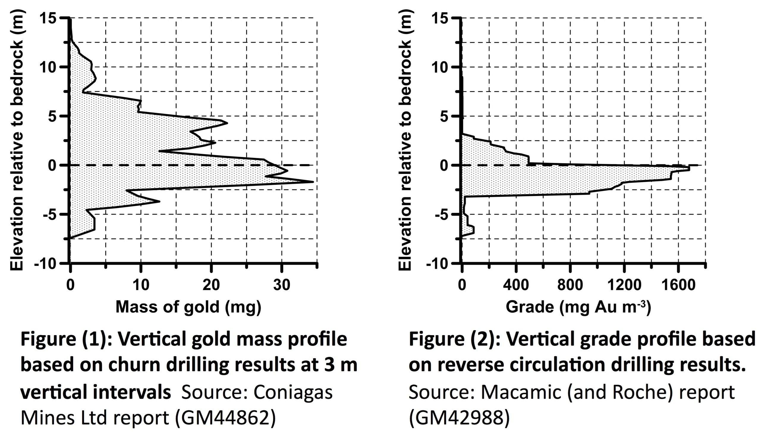
The two graphs, Figures (1) and (2), are comparable only in the gold concentration versus elevation. Nevertheless, part of the differences between the graphs may result from the different performances of the two drilling systems. RC drilling is prone to creating a common effect known as “drag ore” in that they frequently contaminate the bedrock with gold particles derived from gravels at a higher elevation. To a lesser extent, we may see this effect with churn drilling. However, this is somewhat negated by sonic drilling that recuperates complete drill cores of unconsolidated material and hard rock that allows for the extraction of insitu gold grains. In 1985 sonic drilling by the Geological Survey of Canada extracted gold nuggets from 2 feet of saprolite (Hole #20, 27g/m3). In 2011 UBR pulled gold grains from saprolite drill cores G65-SO6.
Historical Paleoplacer Gold Deposit Open At Depth & Laterally
All five historical overburden drill programs from 1959 to 2011 aimed to test the basal auriferous till unit of the paleoplacer channel for its economic potential. A hole was considered completed after a drill run through the basal till layer into approximately 1 meter of saprolite. The Company believes that past operators stopped their drill holes prematurely; consequently, results might have been different had they drilled entirely through the saprolite layer down to solid fresh shale bedrock.
An example of this disparity is Macamic’s 1987 RC dill hole G80-2 drilled only 0.6 meters in the fractured shales extracting coarse gold valued at 3.6 g/m3. In the Company’s 2021 Diamond Drill hole SM-21-30, the saprolite/fractured rock is at least 1.6 vertical meters thick in this area. According to the Company’s 2021 Diamond Drill program, the saprolite and the highly fractured and oxidized shale zones developed, on average, over 8.8 meters of vertical depth in the rock. There are places where these zones are more than 18 meters deep.
The historical overburden drill programs positioned their drill lines perpendicular to the paleoplacer channel for cross-section profiles. On seven drill lines, the borehole at the end of a section was mineralized, and, therefore zone remains open laterally. In other words, the section or “drill line” should have been closed with additional holes to confirm whether the mineralized gold zones continue. Examples of the highest gold grades with open sections:
- Hole G49-6 furthest hole to the right = 5.82 g/m3
- Hole G38-8 furthest hole to the right = 1.48 g/m3
- Hole G53-2 furthest hole to the right = 3.31 g/m3
- Hole G59-2 furthest hole to the left = 0.53 g/m3
- Hole G64-3 furthest hole to the right = 6.43 g/m3
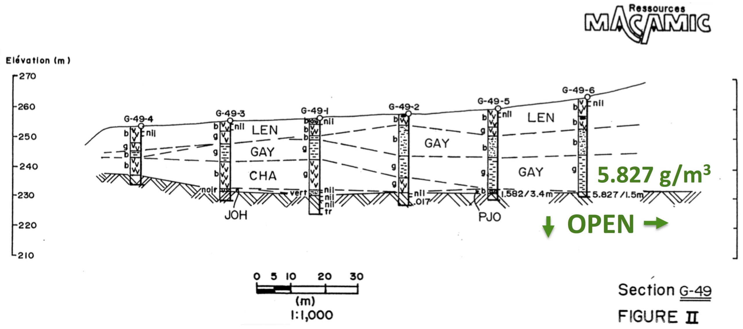
Figure 3: Drill hole G-49-6 stopped at 1.5 meters in a mineralized (5.82gr/m3) mixture of gravel and fractured shale. Macamic should have sampled the till segment above the mineralization, drill deeper into it and drilled additional holes to the right to close the zone.
Of the Company’s 38 DDH 2021 program, 25 holes recuperated a total of 275 meters of drilled core segments of saprolite and oxidized shale layers. The cores will be analyzed for coarse gold content. More sonic drill holes would be needed to test the saprolite units for gold to confirm that the paleoplacer channel is open at depth and laterally.
Sources and references: Sedar- Beauce Gold Fields 43-101 Report – Beauce July 4th 2018, Author B. Violette; VGP Reference (vertical grade profile): Garnett, R.H.T., 2014. “Vertical grade profiles of offshore and coastal placers”. Applied Earth Science (Trans. Inst. Min. Metall. B), vol. 123, no. 3, pp. 164-178.; Coniagas Mines Ltd. Report GM42988, Macamic (and Roche) report GM46219
Jean Bernard, B,Sc. Geo., is a qualified person, as defined by NI 43-101, who has reviewed and approved the technical information presented in this release.

Beauce Gold Fields is a gold exploration company focused on placer to hard rock exploration in the Beauce region of Southern Quebec.