Montreal, Quebec — Beauce Gold Fields (Champs D’Or en Beauce) (TSXV: ¨BGF¨), (“BGF”): (“BGF” or the “Company”): is pleased to announce it has received preliminary results for the Ditton Gold project located near the town of Chartierville in the southern Megantic region of Quebec. Results indicate that the gold grains are widely distributed across the placer channel and in the pit of the Ditton sand & gravel quarry.
Patrick Levasseur, President and CEO of Beauce Gold Fields, said, “Finding gold grains over such a large area is strong indicator that the Ditton placer gold channel could of significant size.” Mr. Levasseur further stated, “Our objectives are to evaluate the potential for an economic placer gold deposit and to find indications that could lead to future bedrock lode gold discoveries.”
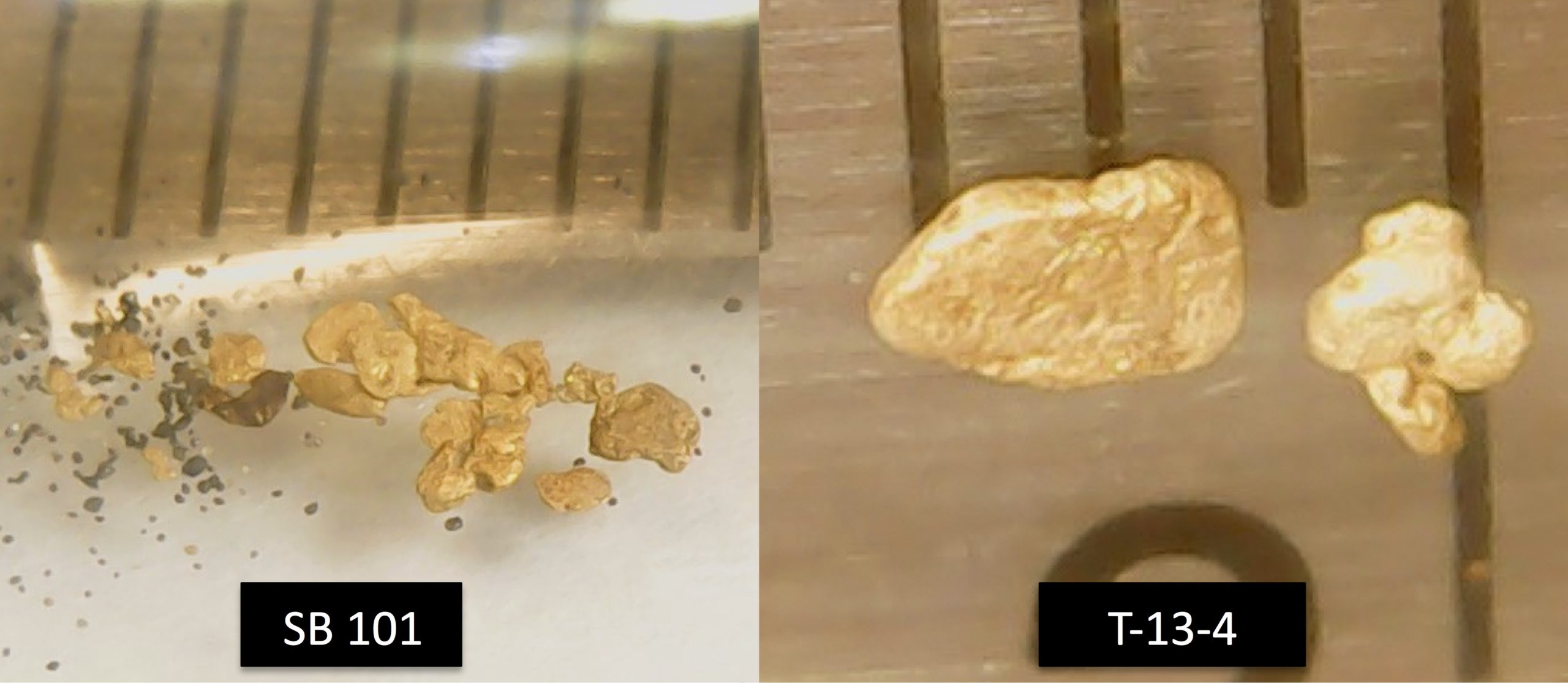
Image 1: Coarse gold grains trench sample SB-101 and bulk Sample T-13-4. Two samples taken from the quarry floor of the Ditton sand & gravel pit; Ruler scale 1mm
Ditton Sector Exploration Update:
In the summer and fall of 2020, the Company completed a 180 bulk sampling program to test the quaternary and tertiary till overburden collected along the Ditton placer channel identified by the summer geophysics survey, the Chesham sand & gravel deposit, as well as the Emberton sector and other high-priority targets. It also included samples dredged from 3 Ditton sand & gravel quarry trenches. (BGF press release 2022-10-18).
Preliminary results indicate gold particles of different sizes were observed in 6 meters deep of sedimentary layers of surface deposits above the placer channel identified (See Maps Image Rang Dix est and Rang Dix Ouest, Gold showings indicated by yellow squares). The program also confirmed that layers of till overburden carrying placer gold now extend to more than 1000 meters to the northeast and possibly more than 400m wide. It also suggests that the gold zone is open to the northeast and the southwest of Rang Dix road.
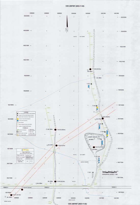
BGF Ditton Map West
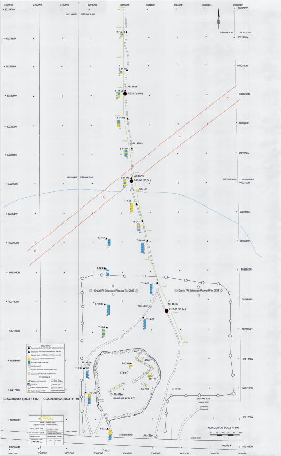
BGF Ditton Map East
In the fall of 2022, 10 sonic drill holes were completed, positioned over a 600-meter segment of the Ditton placer channel. The deepest hole drilled through overburden in bedrock was 39.6 meters deep, the shallowest being 13.7 meters for a total length of 272.9 meters. The drilling successfully recovered 270 meters of 6-inch core samples, allowing the characterization of quaternary and tertiary overburden layers and bedrock geology.
The operating Ditton (Blais) quarry, which was excavated out of more than 20 meters deep in unconsolidated glacial till deposits, is located just north of Range X and about 300m southeast of the presumed Ditton placer channel. Recent samples taken from the quarry floor were in contact with sheared volcanic rock. They demonstrated the presence of significant gold (Samples SB-101, T-13-4). Several grains of gold up to 3mm in length are coarse and delicate and extracted from cemented brown tertiary gravel. Other coarse gold grains were taken from gravel at various locations on the quarry floor.
All bulk and drill core samples have been reduced to heavy mineral concentrates. Gold grain count, weight, and characterization are still in progress at the Coalia Laboratory in Thetford Mines, Quebec. The heavy mineral concentrates are sent to a laboratory to assay for non-visible gold. The combined results of the assays and weighted gold per sample will be reported in grams per cubic meter.
Jean Bernard, B,Sc. Geo., is a qualified person, as defined by NI 43-101, who has reviewed and approved the technical information presented in this release.
About The Ditton Placer Channel
The placer channel is in the town of Chartierville, Quebec. The channel is 4 km east of the historical Mining Brook placer gold mine and 6 km northwest of the US New Hampshire border. It is also located 115 km south of the Company’s Beauce Gold project in St-Simon-Les-Mine.
A sampling program by the Company recovered gold from every sample taken throughout the Ditton quarry (BGF press release January 20, 2022) brought about the discovery of the Ditton placer gold channel. Further insights were gained from the study of 1980’s historical exploration reports of the regional geology that revealed that the quarry was an excavated pit of an Eastern lip of an exposed layer of a Tertiary placer channel. (GM42843).
Potential for Lode Gold Discoveries
The gold particles from the Ditton sand quarry showed delicate angular shapes suggesting little transportation. A proximal bedrock source of the placer channel could be from the eroded Eastern flank of the valley wall. The bedrock lithology holds a contact point between altered volcanic rock and schist rock. Historical surveys indicated strong magnetic lineaments favourable to hosting gold-bearing quartz lenses.
The Bella Fault line is estimated to run along strike 1 km east of the placer channel where Cache Exploration in 1985 put down 3 diamond drill holes (DDH) along Rang Dix road to test a strong shear zone. The holes intersected andesites containing numerous quartz stringers mineralized with pyrite and much tourmaline. Of interest, in the drill log for DDH number S-2 states that visible gold was noted at 240 meters (GM42843). Cache did not complete the recommended follow-up drilling to test this anomaly.
Jean Bernard, B,Sc. Geo., is a qualified person as defined by NI 43-101 who has reviewed and approved the technical information presented in this release.

Beauce Gold Fields is a gold exploration company focused on placer to hard rock exploration in the Beauce region of Southern Quebec.