Montreal, Quebec — Beauce Gold Fields (Champs D’Or en Beauce) (TSXV: ¨BGF¨), (“BGF”), is pleased to announce that it has completed the first drill program to test numerous high-priority targets on the Company’s Beauce Gold property located in Saint-Simon-les-Mines, Quebec. All 38 diamond drill holes totalled 4,585 meters. All holes have intersected significant widths and over 1,000 meters in length of favourable mineralized structures along multiple strike zones trending parallel to the historical placer gold channel.
Patrick Levasseur, President and CEO of Beauce Gold Fields said, “Another first for this historical placer gold property. We are very excited that our diamond drill program has identified a 1 KM long mineralized corridor, that is part of a gold bearing system in the bedrock first identified by our surface work.” Mr. Levasseur added: “We look forward to receiving assay results and to continue building our understanding of these newly discovered mineralized structures. Results thus far increase our confidence that this could lead us to a lode gold discovery and to the possible source of the historical placer gold deposit.”
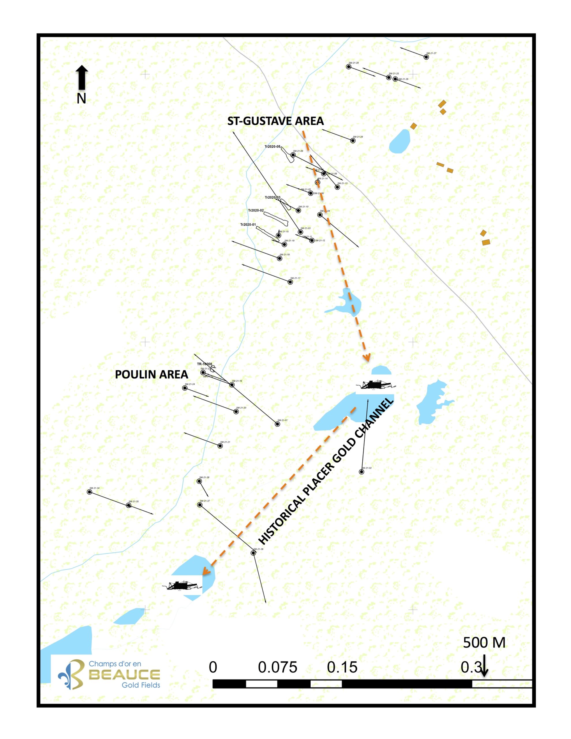
Featured Image: Figure 1: Drill Hole Map of St-Gustave and Poulin Areas.
SAINT-GUSTAVE AREA:
This sector was quickly identified as a priority target, based on previous geophysics, mapping, and trenching work. Notably, the 2020 work by Marc Richer Lafleche PhD Geo., of INRS who identified the presence of visible gold in the trenches TR-2020-01 (Bulk A), TR-2020-02 (Bulk B) and TR-2020-05 (Bulk C). These trenches are spaced more than 200m apart and oriented on an NNE-SSW axis (BGF press release May 12, 2021).
Nineteen (19) boreholes (SM-21-3-5-6-7-8-9-10-11-12-13-14-15-16-17-18-19-25-28-29) were positioned to intercept mineralized zones at depth. The zones extend at least 350m in length. The 300m-deep SM-21-03 was drilled to intersect a gold bearing zone (Busque Tr-2020-51 and Tr-2020-46) at a vertical depth of around 230m. The drilling also tested the zone of gold anomalies found in the trenches at approximately 45m vertical depth. Several short holes were drilled to obtain HQ dimension cores in areas favourable to visible gold mineralization as demonstrated in hole SM-21-08 (BGF press release August 8 2021).
All these 19 holes were drilled along the main mineralized structure (containing gold, arsenopyrite, pyrite, chalcopyrite, sphalerite) covering an area of 1000m in length and by 350m in width. This structure remains open laterally. Many holes have been spaced 30m between the trenches. Others were drilled below tunneling found on the property from the St-Gustave placer gold mine operated by Champs-D’Or Rigaud-Vaudreuil company in the 1910s.
Two step out drill holes (SM-21-26, Sm-21-27) intersected a stockwork zone beneath an outcropping northeast of Rang Saint-Gustave near the Gilbert River. Several blue quartz veins have been noted and sampled for gold.
POULIN AREA
The nine holes (SM-21-01,16 ,20, 21, 22, 23, 24, 34 and 35) were drilled under the Tr-10008 trench (BGF press release January 1, 2019) and the extensions of the anomalous gold zone. Drilling indicates that this zone is developing at depth and laterally and that it would be open on each side of the trench. The arsenopyrite, pyrhotite and chalcopyrite mineralization are more significant in certain holes.
Drilling from the St-Gustave and Poulin areas confirms that the mineralization at Saint-Simon-les-Mines is hosted within a ductile deformation zone which developed mainly in the axial planes of anticline folds. The heterogeneity of the rocks and the contrasting lithological competencies allowed the development of fractured zones which favoured the circulation of mineralizing fluids.
RANG 6 AREA:
Another region that has been investigated is located approximately 700m northeast of Rang Saint-Gustave. A series of four boreholes (SM-21-30 to SM-21-34) were oriented along an NNE-SSW axis which is approximately 450 meters long. The purpose of these holes was to test bedrock structures below the strong placer gold values obtained in the past in the gravels of a small tributary of the Gilbert River (Section G-80-A, 3.65g/m3 Au, 1987 GM46544).
HISTORICAL PLACER GOLD CHANNEL:
Six boreholes (SM-21-2, 4, 36, 37 and 38) were drilled to test structures below sections of the historical placer channel that was mined by a dredging operation in the 1960s. The drilling was also oriented to verify some of the highest gold grades recorded by historical overburden drilling (BGF press release January 21, 2021). Some holes have mineralized quartz veins which will be analyzed. Borehole SM-21-04 was designed to test an induced polarization anomaly.
Drill cores are currently being logged and selected split drill core samples sent to Actlab laboratory for analysis. Further updates will be provided as assay results become available.
The drill program is supervised by Jean Bernard, B,Sc. Geo and is a qualified person as defined by NI 43-101, that has reviewed and approved the technical information presented in this release.
SHARES FOR DEBTS
In accordance with the agreement between BGF and Agora Internet Relations Corp., entered into on August 1, 2020 for the term ending July 31, 2021, BGF Board has approved the issuance of 80,714 common shares at a deemed price of $0.14 per share to pay $11,300 for services rendered during the period from May 1, 2021 ending July 31 2021. Each share issued pursuant to the debt settlement will have a mandatory four (4) month and one (1) day holding period from the date of closing. This debts settlement is subject to the TSX Venture Exchange approval.

Beauce Gold Fields is a gold exploration company focused on placer to hard rock exploration in the Beauce region of Southern Quebec.